You are here: Home > Network List > TA - USArray Transportable Network (new EarthScope stations) Stations List
> Station M04C Macdoel, CA, USA > Earthquake Result Viewer
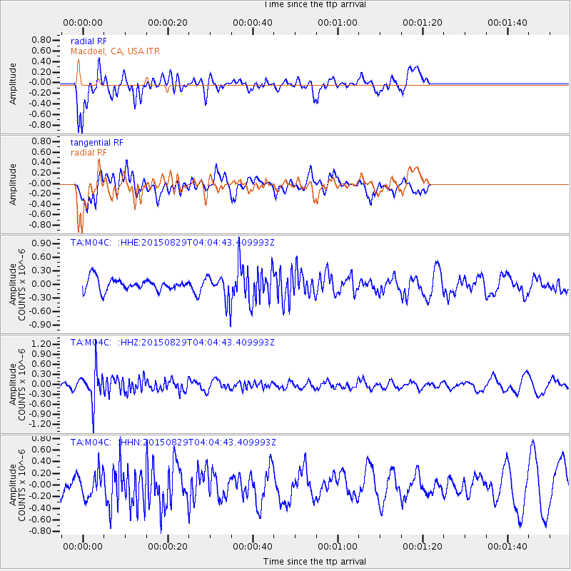
M04C Macdoel, CA, USA - Earthquake Result Viewer
*The percent match for this event was below the threshold and hence no stack was calculated.
| Earthquake location: |
Mariana Islands |
| Earthquake latitude/longitude: |
19.1/145.7 |
| Earthquake time(UTC): |
2015/08/29 (241) 03:53:23 GMT |
| Earthquake Depth: |
124 km |
| Earthquake Magnitude: |
5.5 MB |
| Earthquake Catalog/Contributor: |
NEIC PDE/NEIC COMCAT |
|
| Network: |
TA USArray Transportable Network (new EarthScope stations) |
| Station: |
M04C Macdoel, CA, USA |
| Lat/Lon: |
41.78 N/121.84 W |
| Elevation: |
1391 m |
|
| Distance: |
79.3 deg |
| Az: |
49.5 deg |
| Baz: |
286.022 deg |
| Ray Param: |
$rayparam |
*The percent match for this event was below the threshold and hence was not used in the summary stack. |
|
| Radial Match: |
66.51316 % |
| Radial Bump: |
400 |
| Transverse Match: |
54.66081 % |
| Transverse Bump: |
400 |
| SOD ConfigId: |
7422571 |
| Insert Time: |
2019-04-20 15:25:49.987 +0000 |
| GWidth: |
2.5 |
| Max Bumps: |
400 |
| Tol: |
0.001 |
|
Signal To Noise
| Channel | StoN | STA | LTA |
| TA:M04C: :HHZ:20150829T04:04:43.409993Z | 4.7111363 | 4.8329764E-7 | 1.0258621E-7 |
| TA:M04C: :HHN:20150829T04:04:43.409993Z | 1.0337553 | 2.2106494E-7 | 2.1384648E-7 |
| TA:M04C: :HHE:20150829T04:04:43.409993Z | 2.5296614 | 3.1338178E-7 | 1.238829E-7 |
| Arrivals |
| Ps | |
| PpPs | |
| PsPs/PpSs | |


