You are here: Home > Network List > TA - USArray Transportable Network (new EarthScope stations) Stations List
> Station MDND Maddock, ND, USA > Earthquake Result Viewer
MDND Maddock, ND, USA - Earthquake Result Viewer
*The percent match for this event was below the threshold and hence no stack was calculated.
| Earthquake location: |
Mariana Islands |
| Earthquake latitude/longitude: |
19.1/145.7 |
| Earthquake time(UTC): |
2015/08/29 (241) 03:53:23 GMT |
| Earthquake Depth: |
124 km |
| Earthquake Magnitude: |
5.5 MB |
| Earthquake Catalog/Contributor: |
NEIC PDE/NEIC COMCAT |
|
| Network: |
TA USArray Transportable Network (new EarthScope stations) |
| Station: |
MDND Maddock, ND, USA |
| Lat/Lon: |
47.85 N/99.60 W |
| Elevation: |
479 m |
|
| Distance: |
91.5 deg |
| Az: |
37.733 deg |
| Baz: |
300.806 deg |
| Ray Param: |
$rayparam |
*The percent match for this event was below the threshold and hence was not used in the summary stack. |
|
| Radial Match: |
57.340942 % |
| Radial Bump: |
397 |
| Transverse Match: |
51.202076 % |
| Transverse Bump: |
354 |
| SOD ConfigId: |
7422571 |
| Insert Time: |
2019-04-20 15:25:52.443 +0000 |
| GWidth: |
2.5 |
| Max Bumps: |
400 |
| Tol: |
0.001 |
|
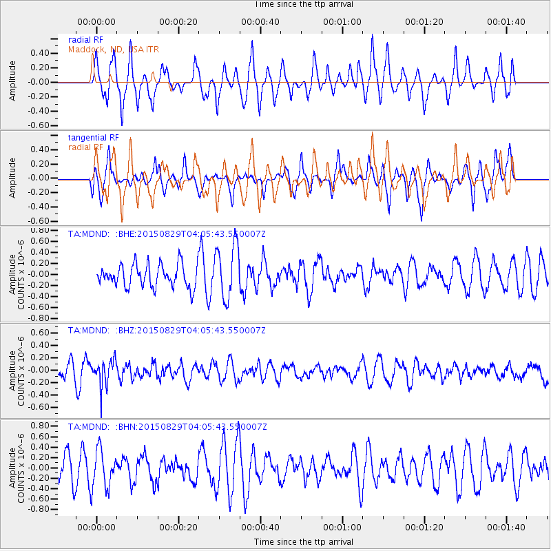
Signal To Noise
| Channel | StoN | STA | LTA |
| TA:MDND: :BHZ:20150829T04:05:43.550007Z | 1.7440747 | 2.1793252E-7 | 1.2495596E-7 |
| TA:MDND: :BHN:20150829T04:05:43.550007Z | 1.2122055 | 3.3535952E-7 | 2.7665237E-7 |
| TA:MDND: :BHE:20150829T04:05:43.550007Z | 1.9886675 | 4.7093948E-7 | 2.3681157E-7 |
| Arrivals |
| Ps | |
| PpPs | |
| PsPs/PpSs | |


