You are here: Home > Network List > TA - USArray Transportable Network (new EarthScope stations) Stations List
> Station O03E Paynes Creek, CA, USA > Earthquake Result Viewer
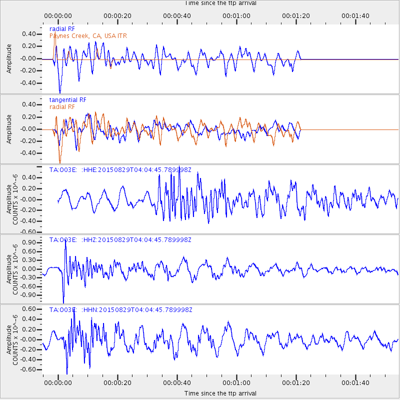
O03E Paynes Creek, CA, USA - Earthquake Result Viewer
*The percent match for this event was below the threshold and hence no stack was calculated.
| Earthquake location: |
Mariana Islands |
| Earthquake latitude/longitude: |
19.1/145.7 |
| Earthquake time(UTC): |
2015/08/29 (241) 03:53:23 GMT |
| Earthquake Depth: |
124 km |
| Earthquake Magnitude: |
5.5 MB |
| Earthquake Catalog/Contributor: |
NEIC PDE/NEIC COMCAT |
|
| Network: |
TA USArray Transportable Network (new EarthScope stations) |
| Station: |
O03E Paynes Creek, CA, USA |
| Lat/Lon: |
40.29 N/121.80 W |
| Elevation: |
967 m |
|
| Distance: |
79.7 deg |
| Az: |
50.944 deg |
| Baz: |
286.309 deg |
| Ray Param: |
$rayparam |
*The percent match for this event was below the threshold and hence was not used in the summary stack. |
|
| Radial Match: |
71.166405 % |
| Radial Bump: |
400 |
| Transverse Match: |
75.8738 % |
| Transverse Bump: |
400 |
| SOD ConfigId: |
7422571 |
| Insert Time: |
2019-04-20 15:25:56.250 +0000 |
| GWidth: |
2.5 |
| Max Bumps: |
400 |
| Tol: |
0.001 |
|
Signal To Noise
| Channel | StoN | STA | LTA |
| TA:O03E: :HHZ:20150829T04:04:45.789998Z | 5.538462 | 4.1261907E-7 | 7.450066E-8 |
| TA:O03E: :HHN:20150829T04:04:45.789998Z | 2.1162865 | 2.0905884E-7 | 9.878569E-8 |
| TA:O03E: :HHE:20150829T04:04:45.789998Z | 1.5651709 | 1.9431323E-7 | 1.2414826E-7 |
| Arrivals |
| Ps | |
| PpPs | |
| PsPs/PpSs | |


