You are here: Home > Network List > US - United States National Seismic Network Stations List
> Station DGMT Dagmar, Montana, USA > Earthquake Result Viewer
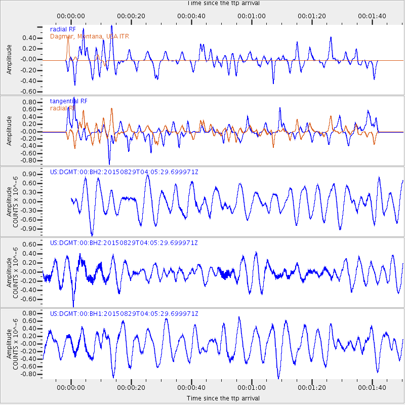
DGMT Dagmar, Montana, USA - Earthquake Result Viewer
*The percent match for this event was below the threshold and hence no stack was calculated.
| Earthquake location: |
Mariana Islands |
| Earthquake latitude/longitude: |
19.1/145.7 |
| Earthquake time(UTC): |
2015/08/29 (241) 03:53:23 GMT |
| Earthquake Depth: |
124 km |
| Earthquake Magnitude: |
5.5 MB |
| Earthquake Catalog/Contributor: |
NEIC PDE/NEIC COMCAT |
|
| Network: |
US United States National Seismic Network |
| Station: |
DGMT Dagmar, Montana, USA |
| Lat/Lon: |
48.47 N/104.20 W |
| Elevation: |
0.0 m |
|
| Distance: |
88.5 deg |
| Az: |
38.685 deg |
| Baz: |
297.395 deg |
| Ray Param: |
$rayparam |
*The percent match for this event was below the threshold and hence was not used in the summary stack. |
|
| Radial Match: |
54.044014 % |
| Radial Bump: |
400 |
| Transverse Match: |
47.98858 % |
| Transverse Bump: |
332 |
| SOD ConfigId: |
7422571 |
| Insert Time: |
2019-04-20 15:26:42.940 +0000 |
| GWidth: |
2.5 |
| Max Bumps: |
400 |
| Tol: |
0.001 |
|
Signal To Noise
| Channel | StoN | STA | LTA |
| US:DGMT:00:BHZ:20150829T04:05:29.699971Z | 1.8932745 | 3.010142E-7 | 1.5899131E-7 |
| US:DGMT:00:BH1:20150829T04:05:29.699971Z | 0.5327646 | 2.2686757E-7 | 4.258308E-7 |
| US:DGMT:00:BH2:20150829T04:05:29.699971Z | 0.6735332 | 2.93633E-7 | 4.359592E-7 |
| Arrivals |
| Ps | |
| PpPs | |
| PsPs/PpSs | |


