You are here: Home > Network List > UW - Pacific Northwest Regional Seismic Network Stations List
> Station LEBA Lebam, WA, USA > Earthquake Result Viewer
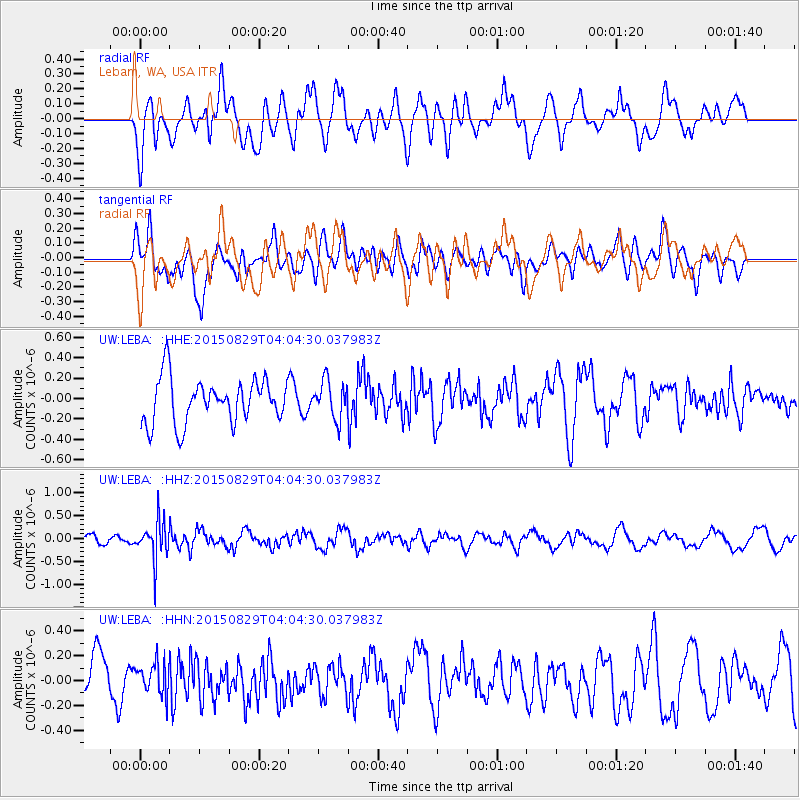
LEBA Lebam, WA, USA - Earthquake Result Viewer
*The percent match for this event was below the threshold and hence no stack was calculated.
| Earthquake location: |
Mariana Islands |
| Earthquake latitude/longitude: |
19.1/145.7 |
| Earthquake time(UTC): |
2015/08/29 (241) 03:53:23 GMT |
| Earthquake Depth: |
124 km |
| Earthquake Magnitude: |
5.5 MB |
| Earthquake Catalog/Contributor: |
NEIC PDE/NEIC COMCAT |
|
| Network: |
UW Pacific Northwest Regional Seismic Network |
| Station: |
LEBA Lebam, WA, USA |
| Lat/Lon: |
46.55 N/123.56 W |
| Elevation: |
73 m |
|
| Distance: |
76.9 deg |
| Az: |
45.127 deg |
| Baz: |
283.92 deg |
| Ray Param: |
$rayparam |
*The percent match for this event was below the threshold and hence was not used in the summary stack. |
|
| Radial Match: |
49.71948 % |
| Radial Bump: |
400 |
| Transverse Match: |
70.63025 % |
| Transverse Bump: |
400 |
| SOD ConfigId: |
7422571 |
| Insert Time: |
2019-04-20 15:26:58.627 +0000 |
| GWidth: |
2.5 |
| Max Bumps: |
400 |
| Tol: |
0.001 |
|
Signal To Noise
| Channel | StoN | STA | LTA |
| UW:LEBA: :HHZ:20150829T04:04:30.037983Z | 3.6199322 | 4.3053362E-7 | 1.1893417E-7 |
| UW:LEBA: :HHN:20150829T04:04:30.037983Z | 0.6461257 | 1.2933431E-7 | 2.0016897E-7 |
| UW:LEBA: :HHE:20150829T04:04:30.037983Z | 0.99027485 | 2.1681322E-7 | 2.1894246E-7 |
| Arrivals |
| Ps | |
| PpPs | |
| PsPs/PpSs | |


