You are here: Home > Network List > GS - US Geological Survey Networks Stations List
> Station OK031 2598 S. Brethren Rd., Cushing, OK, USA > Earthquake Result Viewer
OK031 2598 S. Brethren Rd., Cushing, OK, USA - Earthquake Result Viewer
| Earthquake location: |
Southeast Of Honshu, Japan |
| Earthquake latitude/longitude: |
31.6/140.2 |
| Earthquake time(UTC): |
2015/05/02 (122) 16:50:46 GMT |
| Earthquake Depth: |
32 km |
| Earthquake Magnitude: |
5.7 MB |
| Earthquake Catalog/Contributor: |
NEIC PDE/NEIC ALERT |
|
| Network: |
GS US Geological Survey Networks |
| Station: |
OK031 2598 S. Brethren Rd., Cushing, OK, USA |
| Lat/Lon: |
35.95 N/96.84 W |
| Elevation: |
290 m |
|
| Distance: |
94.1 deg |
| Az: |
43.024 deg |
| Baz: |
314.143 deg |
| Ray Param: |
0.04109944 |
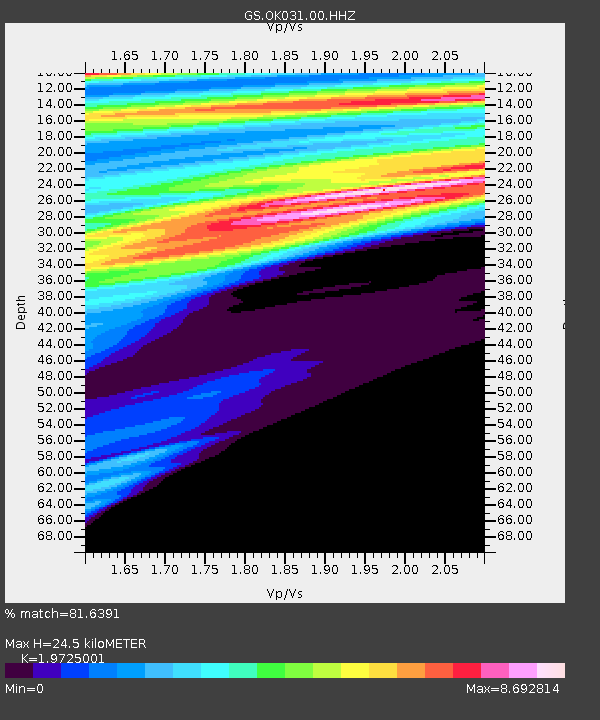
| Estimated Moho Depth: |
24.5 km |
| Estimated Crust Vp/Vs: |
1.97 |
| Assumed Crust Vp: |
6.426 km/s |
| Estimated Crust Vs: |
3.258 km/s |
| Estimated Crust Poisson's Ratio: |
0.33 |
|
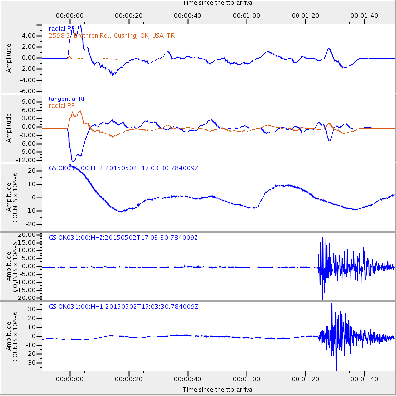
| Radial Match: |
81.6391 % |
| Radial Bump: |
400 |
| Transverse Match: |
74.359795 % |
| Transverse Bump: |
400 |
| SOD ConfigId: |
872571 |
| Insert Time: |
2015-05-16 17:08:27.076 +0000 |
| GWidth: |
2.5 |
| Max Bumps: |
400 |
| Tol: |
0.001 |
|
Signal To Noise
| Channel | StoN | STA | LTA |
| GS:OK031:00:HHZ:20150502T17:03:30.784009Z | 0.70372456 | 1.410496E-7 | 2.0043296E-7 |
| GS:OK031:00:HH1:20150502T17:03:30.784009Z | 1.0690112 | 5.14464E-6 | 4.812522E-6 |
| GS:OK031:00:HH2:20150502T17:03:30.784009Z | 0.18731113 | 2.2062716E-6 | 1.1778647E-5 |
| Arrivals |
| Ps | 3.8 SECOND |
| PpPs | 11 SECOND |
| PsPs/PpSs | 15 SECOND |


