You are here: Home > Network List > TA - USArray Transportable Network (new EarthScope stations) Stations List
> Station R11A Troy Canyon, Currant, NV, USA > Earthquake Result Viewer
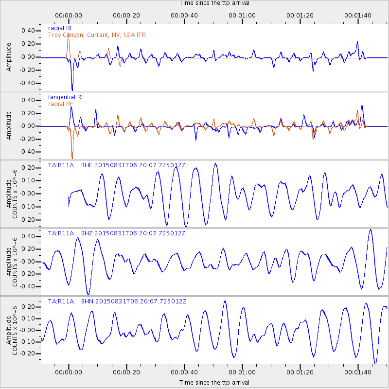
R11A Troy Canyon, Currant, NV, USA - Earthquake Result Viewer
*The percent match for this event was below the threshold and hence no stack was calculated.
| Earthquake location: |
Kermadec Islands Region |
| Earthquake latitude/longitude: |
-31.1/-177.7 |
| Earthquake time(UTC): |
2015/08/31 (243) 06:07:39 GMT |
| Earthquake Depth: |
10 km |
| Earthquake Magnitude: |
5.0 MW |
| Earthquake Catalog/Contributor: |
ISC/ISC |
|
| Network: |
TA USArray Transportable Network (new EarthScope stations) |
| Station: |
R11A Troy Canyon, Currant, NV, USA |
| Lat/Lon: |
38.35 N/115.59 W |
| Elevation: |
1756 m |
|
| Distance: |
90.1 deg |
| Az: |
44.024 deg |
| Baz: |
229.306 deg |
| Ray Param: |
$rayparam |
*The percent match for this event was below the threshold and hence was not used in the summary stack. |
|
| Radial Match: |
68.03512 % |
| Radial Bump: |
400 |
| Transverse Match: |
55.063915 % |
| Transverse Bump: |
400 |
| SOD ConfigId: |
7422571 |
| Insert Time: |
2019-04-20 15:40:58.214 +0000 |
| GWidth: |
2.5 |
| Max Bumps: |
400 |
| Tol: |
0.001 |
|
Signal To Noise
| Channel | StoN | STA | LTA |
| TA:R11A: :BHZ:20150831T06:20:07.725012Z | 4.18112 | 2.803705E-7 | 6.705632E-8 |
| TA:R11A: :BHN:20150831T06:20:07.725012Z | 1.2153476 | 1.13495815E-7 | 9.3385474E-8 |
| TA:R11A: :BHE:20150831T06:20:07.725012Z | 1.7974648 | 1.415858E-7 | 7.876972E-8 |
| Arrivals |
| Ps | |
| PpPs | |
| PsPs/PpSs | |


