You are here: Home > Network List > AV - Alaska Volcano Observatory Stations List
> Station MAPS Pakushin Southeast, Makushin Volcano, Alaska > Earthquake Result Viewer
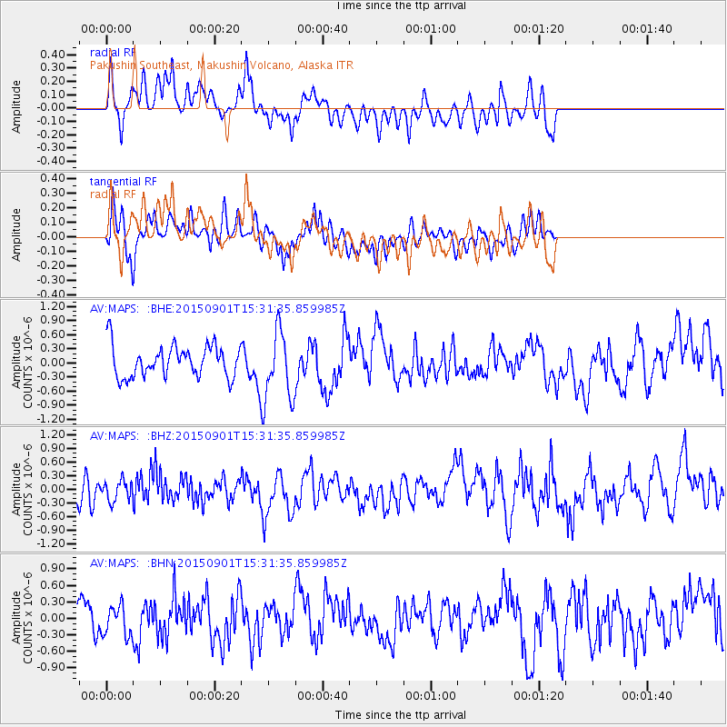
MAPS Pakushin Southeast, Makushin Volcano, Alaska - Earthquake Result Viewer
*The percent match for this event was below the threshold and hence no stack was calculated.
| Earthquake location: |
Southeast Of Honshu, Japan |
| Earthquake latitude/longitude: |
31.3/141.9 |
| Earthquake time(UTC): |
2015/09/01 (244) 15:24:10 GMT |
| Earthquake Depth: |
22 km |
| Earthquake Magnitude: |
5.6 MB |
| Earthquake Catalog/Contributor: |
NEIC PDE/NEIC ALERT |
|
| Network: |
AV Alaska Volcano Observatory |
| Station: |
MAPS Pakushin Southeast, Makushin Volcano, Alaska |
| Lat/Lon: |
53.81 N/166.94 W |
| Elevation: |
333 m |
|
| Distance: |
42.7 deg |
| Az: |
42.951 deg |
| Baz: |
259.407 deg |
| Ray Param: |
$rayparam |
*The percent match for this event was below the threshold and hence was not used in the summary stack. |
|
| Radial Match: |
69.47161 % |
| Radial Bump: |
400 |
| Transverse Match: |
59.68278 % |
| Transverse Bump: |
400 |
| SOD ConfigId: |
7422571 |
| Insert Time: |
2019-04-20 15:43:59.989 +0000 |
| GWidth: |
2.5 |
| Max Bumps: |
400 |
| Tol: |
0.001 |
|
Signal To Noise
| Channel | StoN | STA | LTA |
| AV:MAPS: :BHZ:20150901T15:31:35.859985Z | 0.5939561 | 2.1899054E-7 | 3.686982E-7 |
| AV:MAPS: :BHN:20150901T15:31:35.859985Z | 0.78053045 | 2.811629E-7 | 3.6022027E-7 |
| AV:MAPS: :BHE:20150901T15:31:35.859985Z | 2.1966107 | 7.4050195E-7 | 3.3711117E-7 |
| Arrivals |
| Ps | |
| PpPs | |
| PsPs/PpSs | |


