You are here: Home > Network List > KN - Kyrgyz Seismic Telemetry Network Stations List
> Station KZA KN.KZA > Earthquake Result Viewer
KZA KN.KZA - Earthquake Result Viewer
| Earthquake location: |
Southeast Of Honshu, Japan |
| Earthquake latitude/longitude: |
31.3/141.9 |
| Earthquake time(UTC): |
2015/09/01 (244) 15:24:10 GMT |
| Earthquake Depth: |
22 km |
| Earthquake Magnitude: |
5.6 MB |
| Earthquake Catalog/Contributor: |
NEIC PDE/NEIC ALERT |
|
| Network: |
KN Kyrgyz Seismic Telemetry Network |
| Station: |
KZA KN.KZA |
| Lat/Lon: |
42.08 N/75.25 E |
| Elevation: |
3520 m |
|
| Distance: |
53.2 deg |
| Az: |
301.471 deg |
| Baz: |
78.576 deg |
| Ray Param: |
0.066200875 |
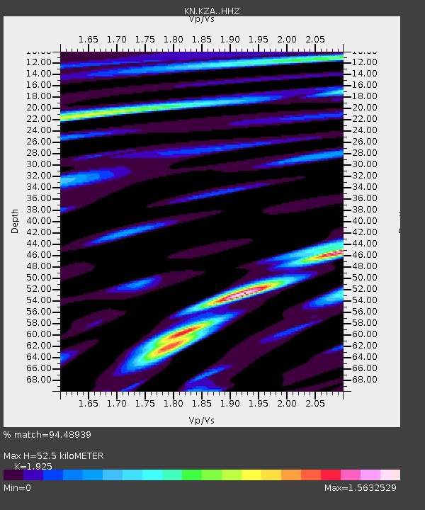
| Estimated Moho Depth: |
52.5 km |
| Estimated Crust Vp/Vs: |
1.92 |
| Assumed Crust Vp: |
6.306 km/s |
| Estimated Crust Vs: |
3.276 km/s |
| Estimated Crust Poisson's Ratio: |
0.32 |
|
| Radial Match: |
94.48939 % |
| Radial Bump: |
400 |
| Transverse Match: |
93.74973 % |
| Transverse Bump: |
400 |
| SOD ConfigId: |
7422571 |
| Insert Time: |
2019-04-20 15:46:28.697 +0000 |
| GWidth: |
2.5 |
| Max Bumps: |
400 |
| Tol: |
0.001 |
|

Signal To Noise
| Channel | StoN | STA | LTA |
| KN:KZA: :HHZ:20150901T15:32:55.51001Z | 16.133953 | 7.506521E-7 | 4.652623E-8 |
| KN:KZA: :HHN:20150901T15:32:55.51001Z | 3.0605667 | 1.5236077E-7 | 4.9781885E-8 |
| KN:KZA: :HHE:20150901T15:32:55.51001Z | 8.7499275 | 3.2734067E-7 | 3.7410672E-8 |
| Arrivals |
| Ps | 8.1 SECOND |
| PpPs | 23 SECOND |
| PsPs/PpSs | 31 SECOND |


