You are here: Home > Network List > KZ - Kazakhstan Network Stations List
> Station KKAR Karatau array,KK31, Kazakhstan > Earthquake Result Viewer
KKAR Karatau array,KK31, Kazakhstan - Earthquake Result Viewer
| Earthquake location: |
Southeast Of Honshu, Japan |
| Earthquake latitude/longitude: |
31.3/141.9 |
| Earthquake time(UTC): |
2015/09/01 (244) 15:24:10 GMT |
| Earthquake Depth: |
22 km |
| Earthquake Magnitude: |
5.6 MB |
| Earthquake Catalog/Contributor: |
NEIC PDE/NEIC ALERT |
|
| Network: |
KZ Kazakhstan Network |
| Station: |
KKAR Karatau array,KK31, Kazakhstan |
| Lat/Lon: |
43.11 N/70.51 E |
| Elevation: |
525 m |
|
| Distance: |
56.4 deg |
| Az: |
303.617 deg |
| Baz: |
76.612 deg |
| Ray Param: |
0.0641106 |
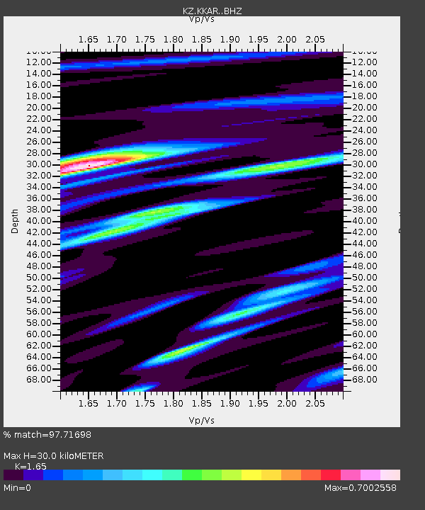
| Estimated Moho Depth: |
30.0 km |
| Estimated Crust Vp/Vs: |
1.65 |
| Assumed Crust Vp: |
6.316 km/s |
| Estimated Crust Vs: |
3.828 km/s |
| Estimated Crust Poisson's Ratio: |
0.21 |
|
| Radial Match: |
97.71698 % |
| Radial Bump: |
352 |
| Transverse Match: |
90.41631 % |
| Transverse Bump: |
400 |
| SOD ConfigId: |
7422571 |
| Insert Time: |
2019-04-20 15:46:44.977 +0000 |
| GWidth: |
2.5 |
| Max Bumps: |
400 |
| Tol: |
0.001 |
|

Signal To Noise
| Channel | StoN | STA | LTA |
| KZ:KKAR: :BHZ:20150901T15:33:18.676025Z | 30.955843 | 2.7802992E-6 | 8.9815E-8 |
| KZ:KKAR: :BHN:20150901T15:33:18.676025Z | 9.73381 | 5.416711E-7 | 5.564841E-8 |
| KZ:KKAR: :BHE:20150901T15:33:18.676025Z | 28.386044 | 1.3207044E-6 | 4.652654E-8 |
| Arrivals |
| Ps | 3.3 SECOND |
| PpPs | 12 SECOND |
| PsPs/PpSs | 15 SECOND |


