You are here: Home > Network List > TJ - Tajikistan National Seismic Network Stations List
> Station SHAA Shaartuz, Tajikistan > Earthquake Result Viewer
SHAA Shaartuz, Tajikistan - Earthquake Result Viewer

| Earthquake location: |
Southeast Of Honshu, Japan |
| Earthquake latitude/longitude: |
31.3/141.9 |
| Earthquake time(UTC): |
2015/09/01 (244) 15:24:10 GMT |
| Earthquake Depth: |
22 km |
| Earthquake Magnitude: |
5.6 MB |
| Earthquake Catalog/Contributor: |
NEIC PDE/NEIC ALERT |
|
| Network: |
TJ Tajikistan National Seismic Network |
| Station: |
SHAA Shaartuz, Tajikistan |
| Lat/Lon: |
37.56 N/68.12 E |
| Elevation: |
868 m |
|
| Distance: |
59.7 deg |
| Az: |
297.916 deg |
| Baz: |
72.056 deg |
| Ray Param: |
0.061991256 |
| Estimated Moho Depth: |
27.5 km |
| Estimated Crust Vp/Vs: |
1.93 |
| Assumed Crust Vp: |
6.213 km/s |
| Estimated Crust Vs: |
3.215 km/s |
| Estimated Crust Poisson's Ratio: |
0.32 |
|
| Radial Match: |
83.837944 % |
| Radial Bump: |
400 |
| Transverse Match: |
83.663284 % |
| Transverse Bump: |
400 |
| SOD ConfigId: |
7422571 |
| Insert Time: |
2019-04-20 15:49:42.475 +0000 |
| GWidth: |
2.5 |
| Max Bumps: |
400 |
| Tol: |
0.001 |
|
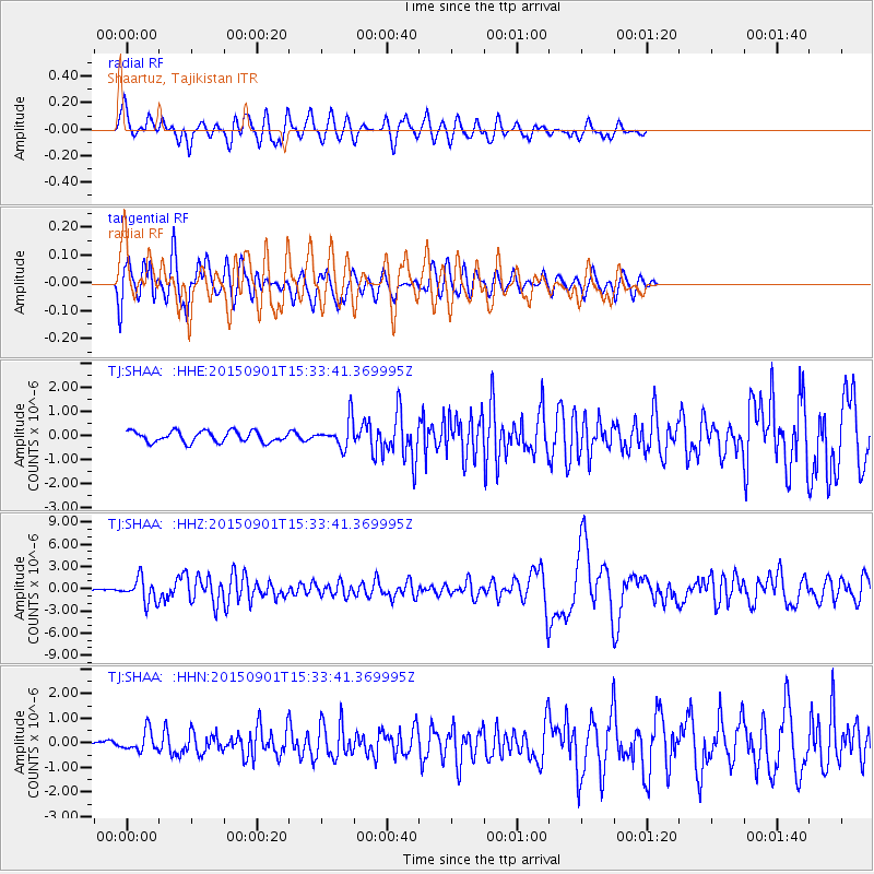
Signal To Noise
| Channel | StoN | STA | LTA |
| TJ:SHAA: :HHZ:20150901T15:33:41.369995Z | 11.6898365 | 1.6365328E-6 | 1.3999622E-7 |
| TJ:SHAA: :HHN:20150901T15:33:41.369995Z | 3.4049838 | 4.118961E-7 | 1.2096861E-7 |
| TJ:SHAA: :HHE:20150901T15:33:41.369995Z | 2.467388 | 5.654299E-7 | 2.2916133E-7 |
| Arrivals |
| Ps | 4.3 SECOND |
| PpPs | 12 SECOND |
| PsPs/PpSs | 17 SECOND |


