You are here: Home > Network List > AV - Alaska Volcano Observatory Stations List
> Station SPCR Ckakachatna River, Mount Spurr, Alaska > Earthquake Result Viewer
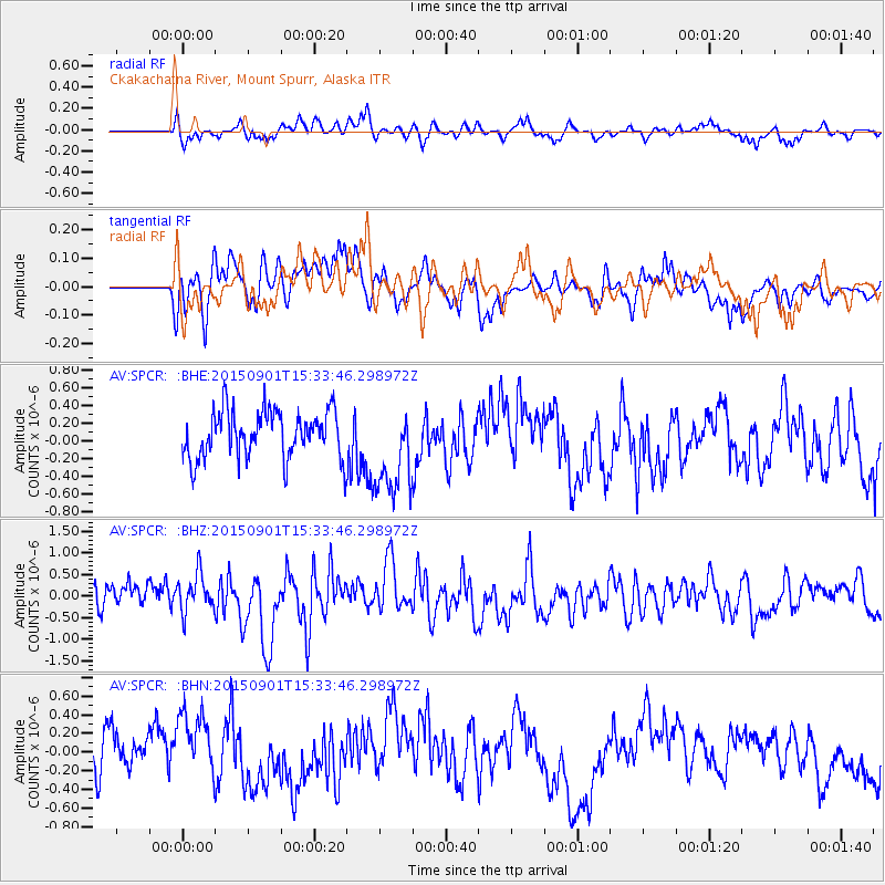
SPCR Ckakachatna River, Mount Spurr, Alaska - Earthquake Result Viewer
*The percent match for this event was below the threshold and hence no stack was calculated.
| Earthquake location: |
Southeast Of Honshu, Japan |
| Earthquake latitude/longitude: |
31.2/141.6 |
| Earthquake time(UTC): |
2015/09/01 (244) 15:25:10 GMT |
| Earthquake Depth: |
13 km |
| Earthquake Magnitude: |
5.6 MB |
| Earthquake Catalog/Contributor: |
NEIC PDE/NEIC COMCAT |
|
| Network: |
AV Alaska Volcano Observatory |
| Station: |
SPCR Ckakachatna River, Mount Spurr, Alaska |
| Lat/Lon: |
61.20 N/152.21 W |
| Elevation: |
984 m |
|
| Distance: |
51.8 deg |
| Az: |
34.3 deg |
| Baz: |
266.107 deg |
| Ray Param: |
$rayparam |
*The percent match for this event was below the threshold and hence was not used in the summary stack. |
|
| Radial Match: |
53.003407 % |
| Radial Bump: |
400 |
| Transverse Match: |
56.288555 % |
| Transverse Bump: |
400 |
| SOD ConfigId: |
7422571 |
| Insert Time: |
2019-04-20 15:53:30.905 +0000 |
| GWidth: |
2.5 |
| Max Bumps: |
400 |
| Tol: |
0.001 |
|
Signal To Noise
| Channel | StoN | STA | LTA |
| AV:SPCR: :BHZ:20150901T15:33:46.298972Z | 1.3826585 | 4.563303E-7 | 3.3003835E-7 |
| AV:SPCR: :BHN:20150901T15:33:46.298972Z | 1.3858411 | 3.6465778E-7 | 2.63131E-7 |
| AV:SPCR: :BHE:20150901T15:33:46.298972Z | 1.7842767 | 4.9028483E-7 | 2.7478072E-7 |
| Arrivals |
| Ps | |
| PpPs | |
| PsPs/PpSs | |


