You are here: Home > Network List > KN - Kyrgyz Seismic Telemetry Network Stations List
> Station CHM KN.CHM > Earthquake Result Viewer
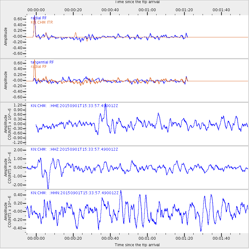
CHM KN.CHM - Earthquake Result Viewer
*The percent match for this event was below the threshold and hence no stack was calculated.
| Earthquake location: |
Southeast Of Honshu, Japan |
| Earthquake latitude/longitude: |
31.2/141.6 |
| Earthquake time(UTC): |
2015/09/01 (244) 15:25:10 GMT |
| Earthquake Depth: |
13 km |
| Earthquake Magnitude: |
5.6 MB |
| Earthquake Catalog/Contributor: |
NEIC PDE/NEIC COMCAT |
|
| Network: |
KN Kyrgyz Seismic Telemetry Network |
| Station: |
CHM KN.CHM |
| Lat/Lon: |
43.00 N/74.75 E |
| Elevation: |
655 m |
|
| Distance: |
53.3 deg |
| Az: |
302.759 deg |
| Baz: |
79.328 deg |
| Ray Param: |
$rayparam |
*The percent match for this event was below the threshold and hence was not used in the summary stack. |
|
| Radial Match: |
78.431915 % |
| Radial Bump: |
400 |
| Transverse Match: |
73.913315 % |
| Transverse Bump: |
400 |
| SOD ConfigId: |
7422571 |
| Insert Time: |
2019-04-20 15:55:43.197 +0000 |
| GWidth: |
2.5 |
| Max Bumps: |
400 |
| Tol: |
0.001 |
|
Signal To Noise
| Channel | StoN | STA | LTA |
| KN:CHM: :HHZ:20150901T15:33:57.490012Z | 5.079002 | 6.720646E-7 | 1.3232219E-7 |
| KN:CHM: :HHN:20150901T15:33:57.490012Z | 1.7376778 | 1.4033671E-7 | 8.076107E-8 |
| KN:CHM: :HHE:20150901T15:33:57.490012Z | 2.6625233 | 3.9549843E-7 | 1.4854272E-7 |
| Arrivals |
| Ps | |
| PpPs | |
| PsPs/PpSs | |


