You are here: Home > Network List > IU - Global Seismograph Network (GSN - IRIS/USGS) Stations List
> Station SJG San Juan, Puerto Rico > Earthquake Result Viewer
SJG San Juan, Puerto Rico - Earthquake Result Viewer
| Earthquake location: |
Near Coast Of Peru |
| Earthquake latitude/longitude: |
-16.1/-74.0 |
| Earthquake time(UTC): |
2001/07/05 (186) 13:53:48 GMT |
| Earthquake Depth: |
62 km |
| Earthquake Magnitude: |
6.2 MB, 6.6 MW, 6.5 ME |
| Earthquake Catalog/Contributor: |
WHDF/NEIC |
|
| Network: |
IU Global Seismograph Network (GSN - IRIS/USGS) |
| Station: |
SJG San Juan, Puerto Rico |
| Lat/Lon: |
18.11 N/66.15 W |
| Elevation: |
457 m |
|
| Distance: |
34.8 deg |
| Az: |
13.118 deg |
| Baz: |
193.262 deg |
| Ray Param: |
0.07736352 |
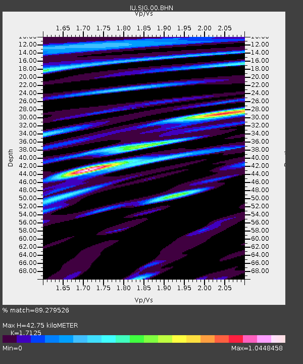
| Estimated Moho Depth: |
42.75 km |
| Estimated Crust Vp/Vs: |
1.71 |
| Assumed Crust Vp: |
5.14 km/s |
| Estimated Crust Vs: |
3.001 km/s |
| Estimated Crust Poisson's Ratio: |
0.24 |
|
| Radial Match: |
89.279526 % |
| Radial Bump: |
395 |
| Transverse Match: |
70.324486 % |
| Transverse Bump: |
400 |
| SOD ConfigId: |
4714 |
| Insert Time: |
2010-03-04 19:01:51.025 +0000 |
| GWidth: |
2.5 |
| Max Bumps: |
400 |
| Tol: |
0.001 |
|
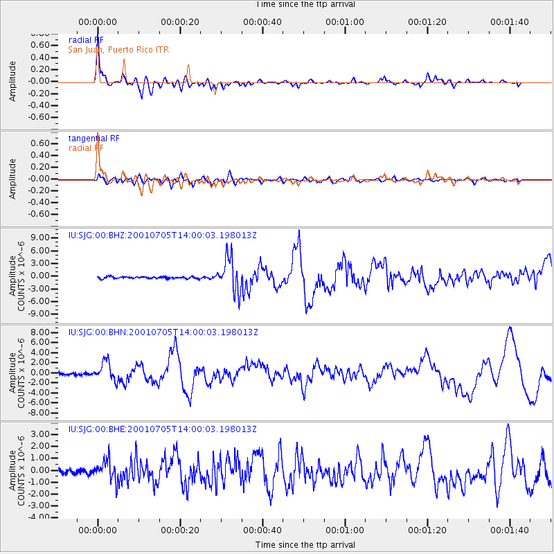
Signal To Noise
| Channel | StoN | STA | LTA |
| IU:SJG:00:BHN:20010705T14:00:03.198013Z | 7.5574055 | 1.936569E-6 | 2.562479E-7 |
| IU:SJG:00:BHE:20010705T14:00:03.198013Z | 4.139656 | 8.4633746E-7 | 2.0444632E-7 |
| IU:SJG:00:BHZ:20010705T14:00:03.198013Z | 20.068903 | 4.139204E-6 | 2.0624964E-7 |
| Arrivals |
| Ps | 6.2 SECOND |
| PpPs | 21 SECOND |
| PsPs/PpSs | 28 SECOND |


