You are here: Home > Network List > CI - Caltech Regional Seismic Network Stations List
> Station MPM Manuel Prospect Mine, California, USA > Earthquake Result Viewer
MPM Manuel Prospect Mine, California, USA - Earthquake Result Viewer
*The percent match for this event was below the threshold and hence no stack was calculated.
| Earthquake location: |
Kuril Islands |
| Earthquake latitude/longitude: |
49.4/155.6 |
| Earthquake time(UTC): |
2015/09/05 (248) 13:16:10 GMT |
| Earthquake Depth: |
47 km |
| Earthquake Magnitude: |
5.9 MWB |
| Earthquake Catalog/Contributor: |
NEIC PDE/NEIC COMCAT |
|
| Network: |
CI Caltech Regional Seismic Network |
| Station: |
MPM Manuel Prospect Mine, California, USA |
| Lat/Lon: |
36.06 N/117.49 W |
| Elevation: |
185 m |
|
| Distance: |
61.8 deg |
| Az: |
66.622 deg |
| Baz: |
312.206 deg |
| Ray Param: |
$rayparam |
*The percent match for this event was below the threshold and hence was not used in the summary stack. |
|
| Radial Match: |
61.0 % |
| Radial Bump: |
400 |
| Transverse Match: |
73.746544 % |
| Transverse Bump: |
398 |
| SOD ConfigId: |
7422571 |
| Insert Time: |
2019-04-20 16:05:06.599 +0000 |
| GWidth: |
2.5 |
| Max Bumps: |
400 |
| Tol: |
0.001 |
|
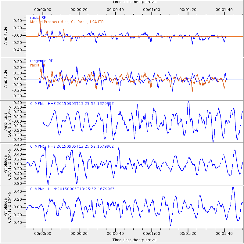
Signal To Noise
| Channel | StoN | STA | LTA |
| CI:MPM: :HHZ:20150905T13:25:52.167996Z | 6.087675 | 5.1822826E-7 | 8.512745E-8 |
| CI:MPM: :HHN:20150905T13:25:52.167996Z | 1.6779286 | 1.5808189E-7 | 9.421253E-8 |
| CI:MPM: :HHE:20150905T13:25:52.167996Z | 1.5359278 | 2.190825E-7 | 1.4263854E-7 |
| Arrivals |
| Ps | |
| PpPs | |
| PsPs/PpSs | |


