You are here: Home > Network List > CN - Canadian National Seismograph Network Stations List
> Station INK INUVIK, NT > Earthquake Result Viewer
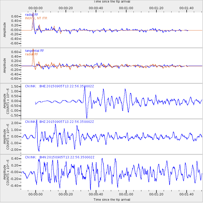
INK INUVIK, NT - Earthquake Result Viewer
*The percent match for this event was below the threshold and hence no stack was calculated.
| Earthquake location: |
Kuril Islands |
| Earthquake latitude/longitude: |
49.4/155.6 |
| Earthquake time(UTC): |
2015/09/05 (248) 13:16:10 GMT |
| Earthquake Depth: |
47 km |
| Earthquake Magnitude: |
5.9 MWB |
| Earthquake Catalog/Contributor: |
NEIC PDE/NEIC COMCAT |
|
| Network: |
CN Canadian National Seismograph Network |
| Station: |
INK INUVIK, NT |
| Lat/Lon: |
68.31 N/133.53 W |
| Elevation: |
44 m |
|
| Distance: |
38.5 deg |
| Az: |
34.307 deg |
| Baz: |
277.564 deg |
| Ray Param: |
$rayparam |
*The percent match for this event was below the threshold and hence was not used in the summary stack. |
|
| Radial Match: |
92.96219 % |
| Radial Bump: |
326 |
| Transverse Match: |
67.58107 % |
| Transverse Bump: |
400 |
| SOD ConfigId: |
7422571 |
| Insert Time: |
2019-04-20 16:05:40.130 +0000 |
| GWidth: |
2.5 |
| Max Bumps: |
400 |
| Tol: |
0.001 |
|
Signal To Noise
| Channel | StoN | STA | LTA |
| CN:INK: :BHZ:20150905T13:22:56.350002Z | 9.011139 | 1.2469728E-6 | 1.3838127E-7 |
| CN:INK: :BHN:20150905T13:22:56.350002Z | 2.165935 | 2.1289841E-7 | 9.8293995E-8 |
| CN:INK: :BHE:20150905T13:22:56.350002Z | 11.392657 | 8.731693E-7 | 7.664317E-8 |
| Arrivals |
| Ps | |
| PpPs | |
| PsPs/PpSs | |


