You are here: Home > Network List > IU - Global Seismograph Network (GSN - IRIS/USGS) Stations List
> Station POHA Pohakuloa, Hawaii, USA > Earthquake Result Viewer
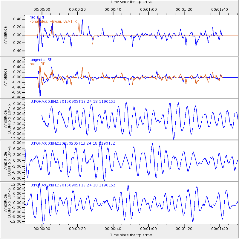
POHA Pohakuloa, Hawaii, USA - Earthquake Result Viewer
*The percent match for this event was below the threshold and hence no stack was calculated.
| Earthquake location: |
Kuril Islands |
| Earthquake latitude/longitude: |
49.4/155.6 |
| Earthquake time(UTC): |
2015/09/05 (248) 13:16:10 GMT |
| Earthquake Depth: |
47 km |
| Earthquake Magnitude: |
5.9 MWB |
| Earthquake Catalog/Contributor: |
NEIC PDE/NEIC COMCAT |
|
| Network: |
IU Global Seismograph Network (GSN - IRIS/USGS) |
| Station: |
POHA Pohakuloa, Hawaii, USA |
| Lat/Lon: |
19.76 N/155.53 W |
| Elevation: |
1990 m |
|
| Distance: |
48.7 deg |
| Az: |
109.379 deg |
| Baz: |
319.086 deg |
| Ray Param: |
$rayparam |
*The percent match for this event was below the threshold and hence was not used in the summary stack. |
|
| Radial Match: |
48.218334 % |
| Radial Bump: |
400 |
| Transverse Match: |
55.635353 % |
| Transverse Bump: |
303 |
| SOD ConfigId: |
7422571 |
| Insert Time: |
2019-04-20 16:07:28.092 +0000 |
| GWidth: |
2.5 |
| Max Bumps: |
400 |
| Tol: |
0.001 |
|
Signal To Noise
| Channel | StoN | STA | LTA |
| IU:POHA:00:BHZ:20150905T13:24:18.119015Z | 0.9402237 | 4.3615355E-6 | 4.6388272E-6 |
| IU:POHA:00:BH1:20150905T13:24:18.119015Z | 2.6942327 | 8.398941E-6 | 3.1173777E-6 |
| IU:POHA:00:BH2:20150905T13:24:18.119015Z | 0.6992062 | 3.2037367E-6 | 4.5819625E-6 |
| Arrivals |
| Ps | |
| PpPs | |
| PsPs/PpSs | |


