You are here: Home > Network List > TA - USArray Transportable Network (new EarthScope stations) Stations List
> Station J20K Nowitna River, AK, USA > Earthquake Result Viewer
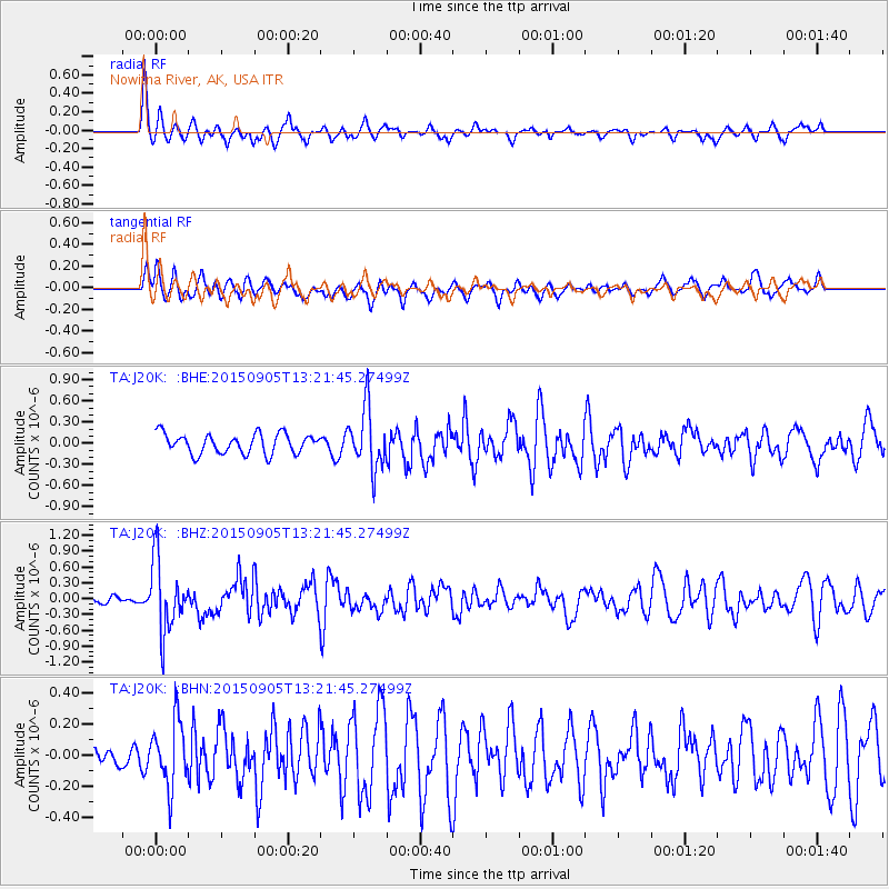
J20K Nowitna River, AK, USA - Earthquake Result Viewer
*The percent match for this event was below the threshold and hence no stack was calculated.
| Earthquake location: |
Kuril Islands |
| Earthquake latitude/longitude: |
49.4/155.6 |
| Earthquake time(UTC): |
2015/09/05 (248) 13:16:10 GMT |
| Earthquake Depth: |
47 km |
| Earthquake Magnitude: |
5.9 MWB |
| Earthquake Catalog/Contributor: |
NEIC PDE/NEIC COMCAT |
|
| Network: |
TA USArray Transportable Network (new EarthScope stations) |
| Station: |
J20K Nowitna River, AK, USA |
| Lat/Lon: |
64.18 N/154.15 W |
| Elevation: |
314 m |
|
| Distance: |
30.3 deg |
| Az: |
41.847 deg |
| Baz: |
264.905 deg |
| Ray Param: |
$rayparam |
*The percent match for this event was below the threshold and hence was not used in the summary stack. |
|
| Radial Match: |
72.05356 % |
| Radial Bump: |
346 |
| Transverse Match: |
67.83554 % |
| Transverse Bump: |
400 |
| SOD ConfigId: |
7422571 |
| Insert Time: |
2019-04-20 16:13:41.892 +0000 |
| GWidth: |
2.5 |
| Max Bumps: |
400 |
| Tol: |
0.001 |
|
Signal To Noise
| Channel | StoN | STA | LTA |
| TA:J20K: :BHZ:20150905T13:21:45.27499Z | 8.536724 | 6.7586933E-7 | 7.9171976E-8 |
| TA:J20K: :BHN:20150905T13:21:45.27499Z | 2.875662 | 2.0919846E-7 | 7.274792E-8 |
| TA:J20K: :BHE:20150905T13:21:45.27499Z | 3.3449543 | 4.2921997E-7 | 1.2831863E-7 |
| Arrivals |
| Ps | |
| PpPs | |
| PsPs/PpSs | |


