You are here: Home > Network List > TA - USArray Transportable Network (new EarthScope stations) Stations List
> Station K62A Royalston, MA, USA > Earthquake Result Viewer
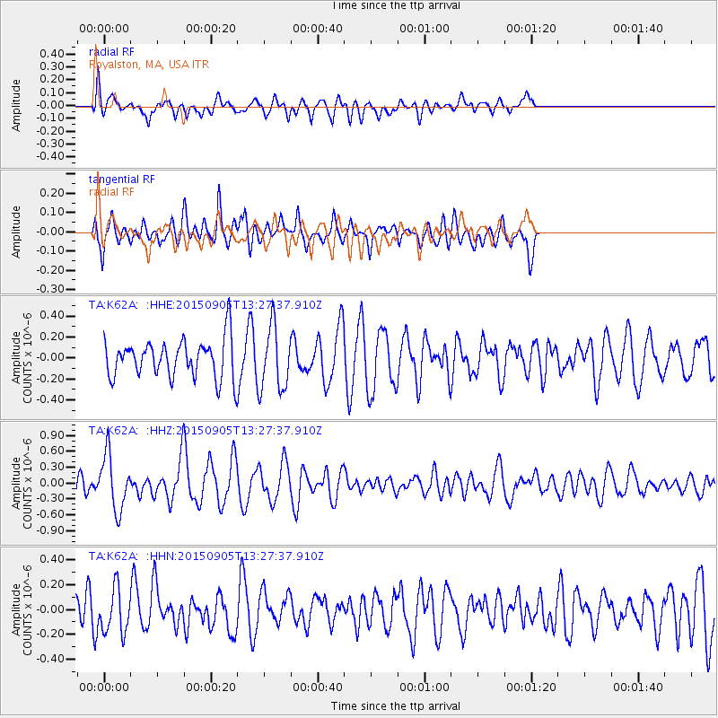
K62A Royalston, MA, USA - Earthquake Result Viewer
*The percent match for this event was below the threshold and hence no stack was calculated.
| Earthquake location: |
Kuril Islands |
| Earthquake latitude/longitude: |
49.4/155.6 |
| Earthquake time(UTC): |
2015/09/05 (248) 13:16:10 GMT |
| Earthquake Depth: |
47 km |
| Earthquake Magnitude: |
5.9 MWB |
| Earthquake Catalog/Contributor: |
NEIC PDE/NEIC COMCAT |
|
| Network: |
TA USArray Transportable Network (new EarthScope stations) |
| Station: |
K62A Royalston, MA, USA |
| Lat/Lon: |
42.67 N/72.23 W |
| Elevation: |
289 m |
|
| Distance: |
79.2 deg |
| Az: |
33.842 deg |
| Baz: |
330.415 deg |
| Ray Param: |
$rayparam |
*The percent match for this event was below the threshold and hence was not used in the summary stack. |
|
| Radial Match: |
41.565163 % |
| Radial Bump: |
392 |
| Transverse Match: |
48.594597 % |
| Transverse Bump: |
370 |
| SOD ConfigId: |
7422571 |
| Insert Time: |
2019-04-20 16:13:50.185 +0000 |
| GWidth: |
2.5 |
| Max Bumps: |
400 |
| Tol: |
0.001 |
|
Signal To Noise
| Channel | StoN | STA | LTA |
| TA:K62A: :HHZ:20150905T13:27:37.910Z | 2.9723446 | 5.240812E-7 | 1.7631913E-7 |
| TA:K62A: :HHN:20150905T13:27:37.910Z | 1.4290545 | 1.7912612E-7 | 1.2534589E-7 |
| TA:K62A: :HHE:20150905T13:27:37.910Z | 1.5418206 | 2.8578032E-7 | 1.8535249E-7 |
| Arrivals |
| Ps | |
| PpPs | |
| PsPs/PpSs | |


