You are here: Home > Network List > TA - USArray Transportable Network (new EarthScope stations) Stations List
> Station L20K Farewell, AK, USA > Earthquake Result Viewer
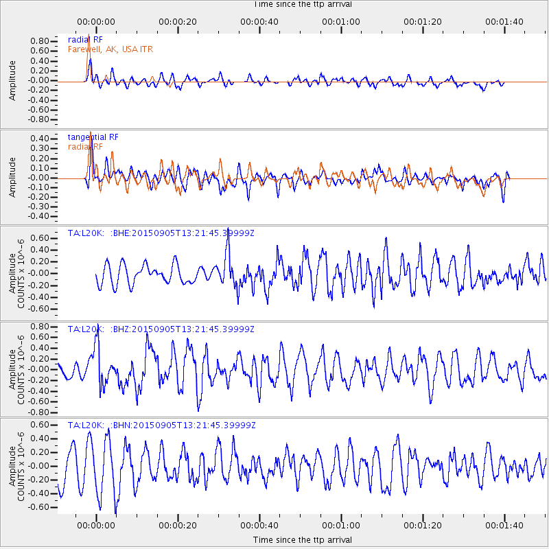
L20K Farewell, AK, USA - Earthquake Result Viewer
*The percent match for this event was below the threshold and hence no stack was calculated.
| Earthquake location: |
Kuril Islands |
| Earthquake latitude/longitude: |
49.4/155.6 |
| Earthquake time(UTC): |
2015/09/05 (248) 13:16:10 GMT |
| Earthquake Depth: |
47 km |
| Earthquake Magnitude: |
5.9 MWB |
| Earthquake Catalog/Contributor: |
NEIC PDE/NEIC COMCAT |
|
| Network: |
TA USArray Transportable Network (new EarthScope stations) |
| Station: |
L20K Farewell, AK, USA |
| Lat/Lon: |
62.48 N/153.88 W |
| Elevation: |
673 m |
|
| Distance: |
30.3 deg |
| Az: |
45.234 deg |
| Baz: |
268.067 deg |
| Ray Param: |
$rayparam |
*The percent match for this event was below the threshold and hence was not used in the summary stack. |
|
| Radial Match: |
57.0671 % |
| Radial Bump: |
400 |
| Transverse Match: |
53.34665 % |
| Transverse Bump: |
400 |
| SOD ConfigId: |
7422571 |
| Insert Time: |
2019-04-20 16:13:54.488 +0000 |
| GWidth: |
2.5 |
| Max Bumps: |
400 |
| Tol: |
0.001 |
|
Signal To Noise
| Channel | StoN | STA | LTA |
| TA:L20K: :BHZ:20150905T13:21:45.39999Z | 2.6072962 | 3.6174765E-7 | 1.3874437E-7 |
| TA:L20K: :BHN:20150905T13:21:45.39999Z | 1.8046334 | 3.9812673E-7 | 2.2061363E-7 |
| TA:L20K: :BHE:20150905T13:21:45.39999Z | 1.9780941 | 2.9937542E-7 | 1.5134539E-7 |
| Arrivals |
| Ps | |
| PpPs | |
| PsPs/PpSs | |


