You are here: Home > Network List > TA - USArray Transportable Network (new EarthScope stations) Stations List
> Station MDND Maddock, ND, USA > Earthquake Result Viewer
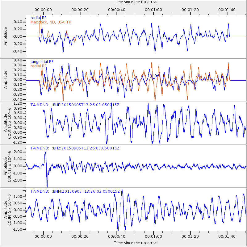
MDND Maddock, ND, USA - Earthquake Result Viewer
*The percent match for this event was below the threshold and hence no stack was calculated.
| Earthquake location: |
Kuril Islands |
| Earthquake latitude/longitude: |
49.4/155.6 |
| Earthquake time(UTC): |
2015/09/05 (248) 13:16:10 GMT |
| Earthquake Depth: |
47 km |
| Earthquake Magnitude: |
5.9 MWB |
| Earthquake Catalog/Contributor: |
NEIC PDE/NEIC COMCAT |
|
| Network: |
TA USArray Transportable Network (new EarthScope stations) |
| Station: |
MDND Maddock, ND, USA |
| Lat/Lon: |
47.85 N/99.60 W |
| Elevation: |
479 m |
|
| Distance: |
63.4 deg |
| Az: |
46.731 deg |
| Baz: |
315.019 deg |
| Ray Param: |
$rayparam |
*The percent match for this event was below the threshold and hence was not used in the summary stack. |
|
| Radial Match: |
66.246765 % |
| Radial Bump: |
379 |
| Transverse Match: |
54.131107 % |
| Transverse Bump: |
400 |
| SOD ConfigId: |
7422571 |
| Insert Time: |
2019-04-20 16:14:04.097 +0000 |
| GWidth: |
2.5 |
| Max Bumps: |
400 |
| Tol: |
0.001 |
|
Signal To Noise
| Channel | StoN | STA | LTA |
| TA:MDND: :BHZ:20150905T13:26:03.050015Z | 5.097754 | 1.1349214E-6 | 2.2263164E-7 |
| TA:MDND: :BHN:20150905T13:26:03.050015Z | 0.9179209 | 4.2866412E-7 | 4.6699463E-7 |
| TA:MDND: :BHE:20150905T13:26:03.050015Z | 1.3402311 | 5.9448877E-7 | 4.4357185E-7 |
| Arrivals |
| Ps | |
| PpPs | |
| PsPs/PpSs | |


