You are here: Home > Network List > TA - USArray Transportable Network (new EarthScope stations) Stations List
> Station N23A Red Feather Lakes, CO, USA > Earthquake Result Viewer
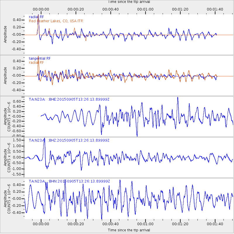
N23A Red Feather Lakes, CO, USA - Earthquake Result Viewer
*The percent match for this event was below the threshold and hence no stack was calculated.
| Earthquake location: |
Kuril Islands |
| Earthquake latitude/longitude: |
49.4/155.6 |
| Earthquake time(UTC): |
2015/09/05 (248) 13:16:10 GMT |
| Earthquake Depth: |
47 km |
| Earthquake Magnitude: |
5.9 MWB |
| Earthquake Catalog/Contributor: |
NEIC PDE/NEIC COMCAT |
|
| Network: |
TA USArray Transportable Network (new EarthScope stations) |
| Station: |
N23A Red Feather Lakes, CO, USA |
| Lat/Lon: |
40.89 N/105.94 W |
| Elevation: |
2458 m |
|
| Distance: |
65.1 deg |
| Az: |
55.76 deg |
| Baz: |
314.515 deg |
| Ray Param: |
$rayparam |
*The percent match for this event was below the threshold and hence was not used in the summary stack. |
|
| Radial Match: |
68.53363 % |
| Radial Bump: |
334 |
| Transverse Match: |
70.48204 % |
| Transverse Bump: |
400 |
| SOD ConfigId: |
7422571 |
| Insert Time: |
2019-04-20 16:14:05.486 +0000 |
| GWidth: |
2.5 |
| Max Bumps: |
400 |
| Tol: |
0.001 |
|
Signal To Noise
| Channel | StoN | STA | LTA |
| TA:N23A: :BHZ:20150905T13:26:13.89999Z | 8.136749 | 7.623441E-7 | 9.369148E-8 |
| TA:N23A: :BHN:20150905T13:26:13.89999Z | 1.6875266 | 2.5484945E-7 | 1.5101952E-7 |
| TA:N23A: :BHE:20150905T13:26:13.89999Z | 2.2007759 | 3.3280878E-7 | 1.512234E-7 |
| Arrivals |
| Ps | |
| PpPs | |
| PsPs/PpSs | |


