You are here: Home > Network List > US - United States National Seismic Network Stations List
> Station DGMT Dagmar, Montana, USA > Earthquake Result Viewer
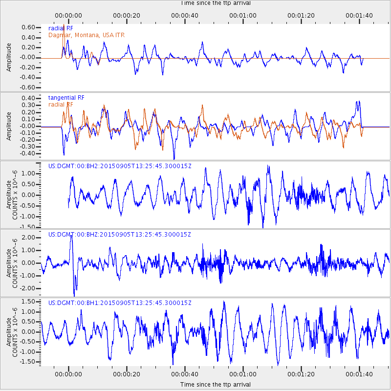
DGMT Dagmar, Montana, USA - Earthquake Result Viewer
*The percent match for this event was below the threshold and hence no stack was calculated.
| Earthquake location: |
Kuril Islands |
| Earthquake latitude/longitude: |
49.4/155.6 |
| Earthquake time(UTC): |
2015/09/05 (248) 13:16:10 GMT |
| Earthquake Depth: |
47 km |
| Earthquake Magnitude: |
5.9 MWB |
| Earthquake Catalog/Contributor: |
NEIC PDE/NEIC COMCAT |
|
| Network: |
US United States National Seismic Network |
| Station: |
DGMT Dagmar, Montana, USA |
| Lat/Lon: |
48.47 N/104.20 W |
| Elevation: |
0.0 m |
|
| Distance: |
60.8 deg |
| Az: |
48.628 deg |
| Baz: |
312.494 deg |
| Ray Param: |
$rayparam |
*The percent match for this event was below the threshold and hence was not used in the summary stack. |
|
| Radial Match: |
68.18055 % |
| Radial Bump: |
400 |
| Transverse Match: |
50.93818 % |
| Transverse Bump: |
384 |
| SOD ConfigId: |
7422571 |
| Insert Time: |
2019-04-20 16:15:06.094 +0000 |
| GWidth: |
2.5 |
| Max Bumps: |
400 |
| Tol: |
0.001 |
|
Signal To Noise
| Channel | StoN | STA | LTA |
| US:DGMT:00:BHZ:20150905T13:25:45.300015Z | 4.6930246 | 1.21702E-6 | 2.593253E-7 |
| US:DGMT:00:BH1:20150905T13:25:45.300015Z | 1.2963878 | 4.95063E-7 | 3.8187878E-7 |
| US:DGMT:00:BH2:20150905T13:25:45.300015Z | 1.1586019 | 4.2994003E-7 | 3.710852E-7 |
| Arrivals |
| Ps | |
| PpPs | |
| PsPs/PpSs | |


