You are here: Home > Network List > UW - Pacific Northwest Regional Seismic Network Stations List
> Station MRBL Marblemount, WA, USA > Earthquake Result Viewer
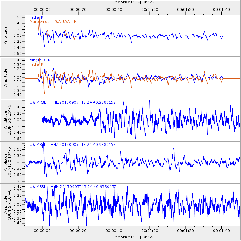
MRBL Marblemount, WA, USA - Earthquake Result Viewer
*The percent match for this event was below the threshold and hence no stack was calculated.
| Earthquake location: |
Kuril Islands |
| Earthquake latitude/longitude: |
49.4/155.6 |
| Earthquake time(UTC): |
2015/09/05 (248) 13:16:10 GMT |
| Earthquake Depth: |
47 km |
| Earthquake Magnitude: |
5.9 MWB |
| Earthquake Catalog/Contributor: |
NEIC PDE/NEIC COMCAT |
|
| Network: |
UW Pacific Northwest Regional Seismic Network |
| Station: |
MRBL Marblemount, WA, USA |
| Lat/Lon: |
48.52 N/121.48 W |
| Elevation: |
75 m |
|
| Distance: |
51.8 deg |
| Az: |
57.146 deg |
| Baz: |
304.291 deg |
| Ray Param: |
$rayparam |
*The percent match for this event was below the threshold and hence was not used in the summary stack. |
|
| Radial Match: |
66.955864 % |
| Radial Bump: |
400 |
| Transverse Match: |
64.85224 % |
| Transverse Bump: |
400 |
| SOD ConfigId: |
7422571 |
| Insert Time: |
2019-04-20 16:15:30.157 +0000 |
| GWidth: |
2.5 |
| Max Bumps: |
400 |
| Tol: |
0.001 |
|
Signal To Noise
| Channel | StoN | STA | LTA |
| UW:MRBL: :HHZ:20150905T13:24:40.938015Z | 4.5393 | 4.153663E-7 | 9.1504475E-8 |
| UW:MRBL: :HHN:20150905T13:24:40.938015Z | 1.6651505 | 1.741923E-7 | 1.0461054E-7 |
| UW:MRBL: :HHE:20150905T13:24:40.938015Z | 2.6707177 | 2.2734697E-7 | 8.51258E-8 |
| Arrivals |
| Ps | |
| PpPs | |
| PsPs/PpSs | |


