You are here: Home > Network List > UW - Pacific Northwest Regional Seismic Network Stations List
> Station UMAT Pilot Rock, OR, USA > Earthquake Result Viewer
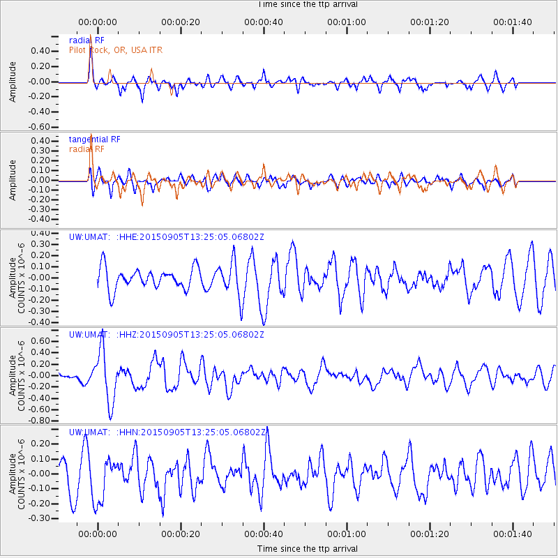
UMAT Pilot Rock, OR, USA - Earthquake Result Viewer
*The percent match for this event was below the threshold and hence no stack was calculated.
| Earthquake location: |
Kuril Islands |
| Earthquake latitude/longitude: |
49.4/155.6 |
| Earthquake time(UTC): |
2015/09/05 (248) 13:16:10 GMT |
| Earthquake Depth: |
47 km |
| Earthquake Magnitude: |
5.9 MWB |
| Earthquake Catalog/Contributor: |
NEIC PDE/NEIC COMCAT |
|
| Network: |
UW Pacific Northwest Regional Seismic Network |
| Station: |
UMAT Pilot Rock, OR, USA |
| Lat/Lon: |
45.29 N/118.96 W |
| Elevation: |
1318 m |
|
| Distance: |
55.0 deg |
| Az: |
59.146 deg |
| Baz: |
307.323 deg |
| Ray Param: |
$rayparam |
*The percent match for this event was below the threshold and hence was not used in the summary stack. |
|
| Radial Match: |
55.98233 % |
| Radial Bump: |
355 |
| Transverse Match: |
50.216095 % |
| Transverse Bump: |
400 |
| SOD ConfigId: |
7422571 |
| Insert Time: |
2019-04-20 16:15:36.299 +0000 |
| GWidth: |
2.5 |
| Max Bumps: |
400 |
| Tol: |
0.001 |
|
Signal To Noise
| Channel | StoN | STA | LTA |
| UW:UMAT: :HHZ:20150905T13:25:05.06802Z | 5.3821144 | 4.6699077E-7 | 8.676716E-8 |
| UW:UMAT: :HHN:20150905T13:25:05.06802Z | 1.7896204 | 1.4841324E-7 | 8.293001E-8 |
| UW:UMAT: :HHE:20150905T13:25:05.06802Z | 2.0665464 | 1.7853507E-7 | 8.6392966E-8 |
| Arrivals |
| Ps | |
| PpPs | |
| PsPs/PpSs | |


