You are here: Home > Network List > XL12 - Hangay Dome, Mongolia Stations List
> Station HV01 HV01 > Earthquake Result Viewer
HV01 HV01 - Earthquake Result Viewer
| Earthquake location: |
Kuril Islands |
| Earthquake latitude/longitude: |
49.4/155.6 |
| Earthquake time(UTC): |
2015/09/05 (248) 13:16:10 GMT |
| Earthquake Depth: |
47 km |
| Earthquake Magnitude: |
5.9 MWB |
| Earthquake Catalog/Contributor: |
NEIC PDE/NEIC COMCAT |
|
| Network: |
XL Hangay Dome, Mongolia |
| Station: |
HV01 HV01 |
| Lat/Lon: |
51.39 N/99.33 E |
| Elevation: |
1539 m |
|
| Distance: |
35.2 deg |
| Az: |
295.324 deg |
| Baz: |
70.627 deg |
| Ray Param: |
0.07722708 |
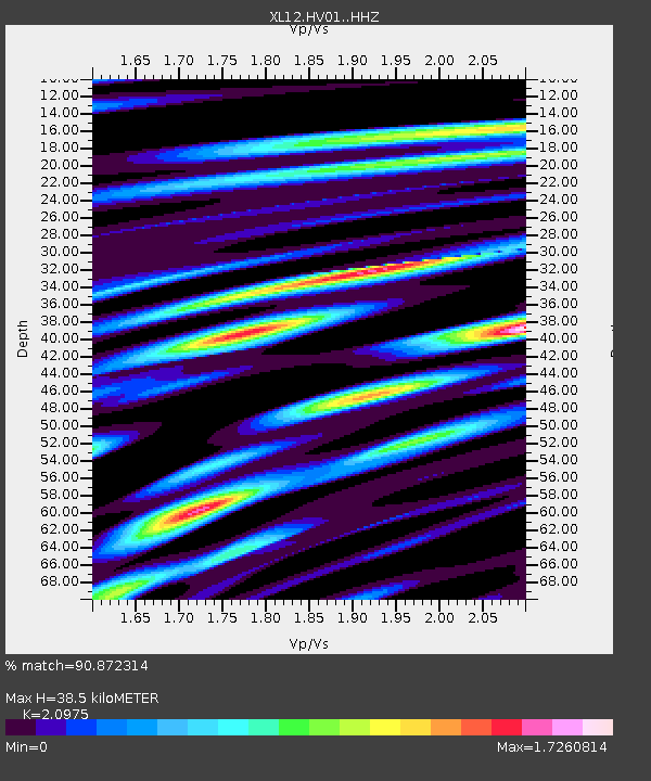
| Estimated Moho Depth: |
38.5 km |
| Estimated Crust Vp/Vs: |
2.10 |
| Assumed Crust Vp: |
6.622 km/s |
| Estimated Crust Vs: |
3.157 km/s |
| Estimated Crust Poisson's Ratio: |
0.35 |
|
| Radial Match: |
90.872314 % |
| Radial Bump: |
400 |
| Transverse Match: |
76.93037 % |
| Transverse Bump: |
400 |
| SOD ConfigId: |
7422571 |
| Insert Time: |
2019-04-20 16:16:54.645 +0000 |
| GWidth: |
2.5 |
| Max Bumps: |
400 |
| Tol: |
0.001 |
|

Signal To Noise
| Channel | StoN | STA | LTA |
| XL:HV01: :HHZ:20150905T13:22:28.519985Z | 9.045331 | 3.186203E-7 | 3.5224836E-8 |
| XL:HV01: :HHN:20150905T13:22:28.519985Z | 1.370228 | 5.5890805E-8 | 4.0789416E-8 |
| XL:HV01: :HHE:20150905T13:22:28.519985Z | 6.805711 | 2.3338188E-7 | 3.4292064E-8 |
| Arrivals |
| Ps | 6.8 SECOND |
| PpPs | 17 SECOND |
| PsPs/PpSs | 24 SECOND |


