You are here: Home > Network List > TA - USArray Transportable Network (new EarthScope stations) Stations List
> Station J04D Umpqua National Forest, Toketee, OR, USA > Earthquake Result Viewer
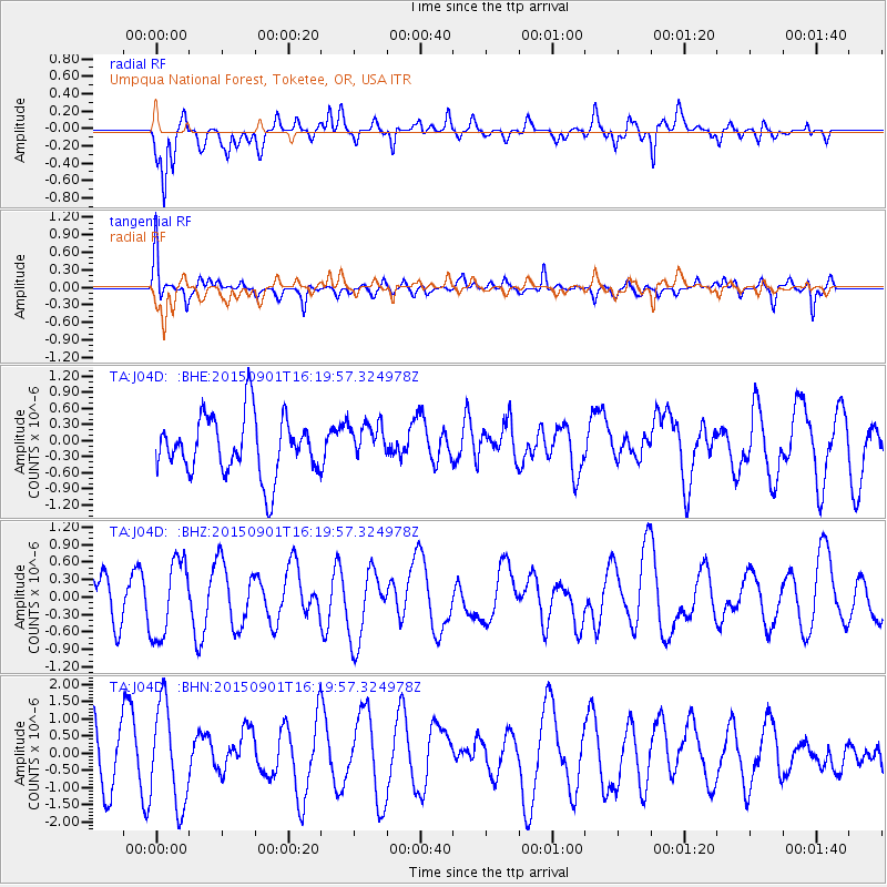
J04D Umpqua National Forest, Toketee, OR, USA - Earthquake Result Viewer
*The percent match for this event was below the threshold and hence no stack was calculated.
| Earthquake location: |
Kermadec Islands Region |
| Earthquake latitude/longitude: |
-29.7/178.7 |
| Earthquake time(UTC): |
2015/09/01 (244) 16:08:26 GMT |
| Earthquake Depth: |
566 km |
| Earthquake Magnitude: |
5.1 mb |
| Earthquake Catalog/Contributor: |
NEIC PDE/us |
|
| Network: |
TA USArray Transportable Network (new EarthScope stations) |
| Station: |
J04D Umpqua National Forest, Toketee, OR, USA |
| Lat/Lon: |
43.24 N/122.11 W |
| Elevation: |
1948 m |
|
| Distance: |
90.6 deg |
| Az: |
38.887 deg |
| Baz: |
228.379 deg |
| Ray Param: |
$rayparam |
*The percent match for this event was below the threshold and hence was not used in the summary stack. |
|
| Radial Match: |
50.02578 % |
| Radial Bump: |
388 |
| Transverse Match: |
53.083458 % |
| Transverse Bump: |
374 |
| SOD ConfigId: |
7422571 |
| Insert Time: |
2019-04-20 16:31:13.993 +0000 |
| GWidth: |
2.5 |
| Max Bumps: |
400 |
| Tol: |
0.001 |
|
Signal To Noise
| Channel | StoN | STA | LTA |
| TA:J04D: :BHZ:20150901T16:19:57.324978Z | 2.37639 | 6.561139E-7 | 2.760969E-7 |
| TA:J04D: :BHN:20150901T16:19:57.324978Z | 1.3921615 | 1.4428599E-6 | 1.0364171E-6 |
| TA:J04D: :BHE:20150901T16:19:57.324978Z | 0.64171183 | 3.5091622E-7 | 5.46844E-7 |
| Arrivals |
| Ps | |
| PpPs | |
| PsPs/PpSs | |


