You are here: Home > Network List > TA - USArray Transportable Network (new EarthScope stations) Stations List
> Station J20K Nowitna River, AK, USA > Earthquake Result Viewer
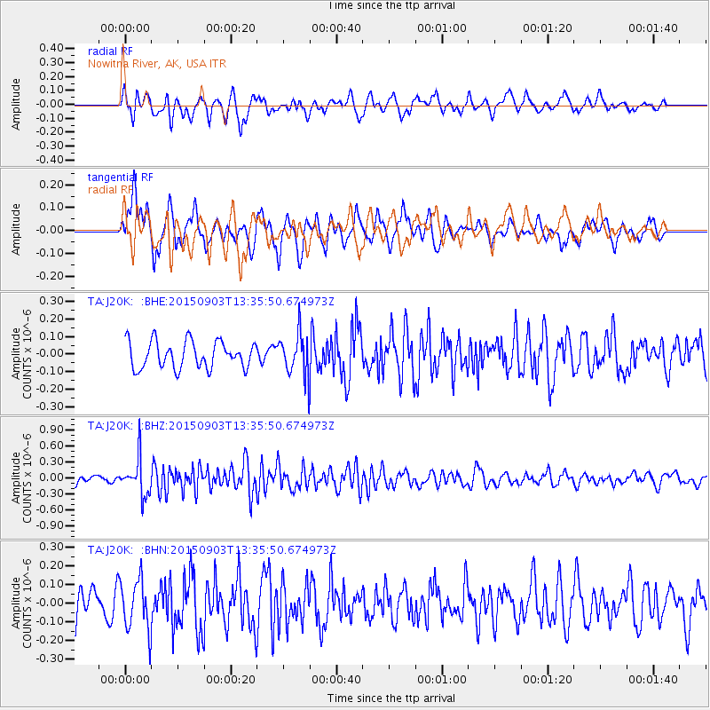
J20K Nowitna River, AK, USA - Earthquake Result Viewer
*The percent match for this event was below the threshold and hence no stack was calculated.
| Earthquake location: |
Northern Molucca Sea |
| Earthquake latitude/longitude: |
2.1/126.7 |
| Earthquake time(UTC): |
2015/09/03 (246) 13:23:59 GMT |
| Earthquake Depth: |
44 km |
| Earthquake Magnitude: |
5.6 MB |
| Earthquake Catalog/Contributor: |
NEIC PDE/NEIC COMCAT |
|
| Network: |
TA USArray Transportable Network (new EarthScope stations) |
| Station: |
J20K Nowitna River, AK, USA |
| Lat/Lon: |
64.18 N/154.15 W |
| Elevation: |
314 m |
|
| Distance: |
83.4 deg |
| Az: |
25.658 deg |
| Baz: |
261.116 deg |
| Ray Param: |
$rayparam |
*The percent match for this event was below the threshold and hence was not used in the summary stack. |
|
| Radial Match: |
59.714203 % |
| Radial Bump: |
400 |
| Transverse Match: |
56.51474 % |
| Transverse Bump: |
400 |
| SOD ConfigId: |
7422571 |
| Insert Time: |
2019-04-20 16:43:36.549 +0000 |
| GWidth: |
2.5 |
| Max Bumps: |
400 |
| Tol: |
0.001 |
|
Signal To Noise
| Channel | StoN | STA | LTA |
| TA:J20K: :BHZ:20150903T13:35:50.674973Z | 4.2499337 | 3.499019E-7 | 8.233115E-8 |
| TA:J20K: :BHN:20150903T13:35:50.674973Z | 1.9842751 | 1.3491515E-7 | 6.799216E-8 |
| TA:J20K: :BHE:20150903T13:35:50.674973Z | 1.6717563 | 1.270476E-7 | 7.599648E-8 |
| Arrivals |
| Ps | |
| PpPs | |
| PsPs/PpSs | |


