You are here: Home > Network List > TA - USArray Transportable Network (new EarthScope stations) Stations List
> Station J20K Nowitna River, AK, USA > Earthquake Result Viewer
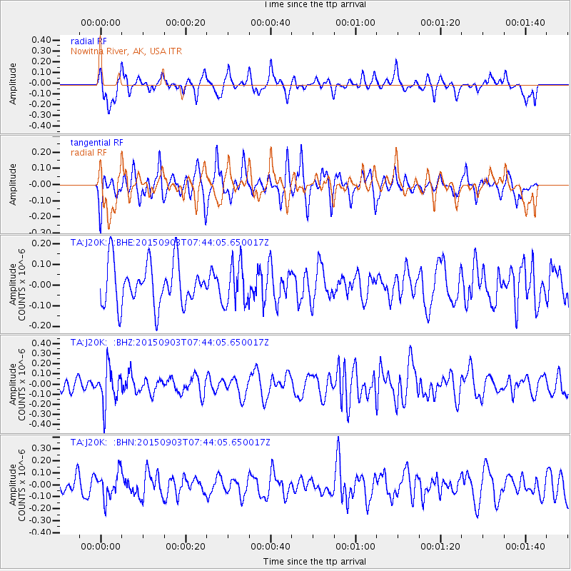
J20K Nowitna River, AK, USA - Earthquake Result Viewer
*The percent match for this event was below the threshold and hence no stack was calculated.
| Earthquake location: |
Tonga Islands |
| Earthquake latitude/longitude: |
-15.5/-174.7 |
| Earthquake time(UTC): |
2015/09/03 (246) 07:32:46 GMT |
| Earthquake Depth: |
212 km |
| Earthquake Magnitude: |
5.2 mb |
| Earthquake Catalog/Contributor: |
NEIC PDE/us |
|
| Network: |
TA USArray Transportable Network (new EarthScope stations) |
| Station: |
J20K Nowitna River, AK, USA |
| Lat/Lon: |
64.18 N/154.15 W |
| Elevation: |
314 m |
|
| Distance: |
81.0 deg |
| Az: |
8.959 deg |
| Baz: |
200.05 deg |
| Ray Param: |
$rayparam |
*The percent match for this event was below the threshold and hence was not used in the summary stack. |
|
| Radial Match: |
65.58112 % |
| Radial Bump: |
384 |
| Transverse Match: |
63.254627 % |
| Transverse Bump: |
363 |
| SOD ConfigId: |
7422571 |
| Insert Time: |
2019-04-20 16:50:24.889 +0000 |
| GWidth: |
2.5 |
| Max Bumps: |
400 |
| Tol: |
0.001 |
|
Signal To Noise
| Channel | StoN | STA | LTA |
| TA:J20K: :BHZ:20150903T07:44:05.650017Z | 1.9022312 | 1.8292329E-7 | 9.6162495E-8 |
| TA:J20K: :BHN:20150903T07:44:05.650017Z | 1.3440894 | 1.1186266E-7 | 8.3225615E-8 |
| TA:J20K: :BHE:20150903T07:44:05.650017Z | 0.9733298 | 9.967207E-8 | 1.02403185E-7 |
| Arrivals |
| Ps | |
| PpPs | |
| PsPs/PpSs | |


