You are here: Home > Network List > TA - USArray Transportable Network (new EarthScope stations) Stations List
> Station R11A Troy Canyon, Currant, NV, USA > Earthquake Result Viewer
R11A Troy Canyon, Currant, NV, USA - Earthquake Result Viewer
*The percent match for this event was below the threshold and hence no stack was calculated.
| Earthquake location: |
Tonga Islands |
| Earthquake latitude/longitude: |
-15.5/-174.7 |
| Earthquake time(UTC): |
2015/09/03 (246) 07:32:46 GMT |
| Earthquake Depth: |
212 km |
| Earthquake Magnitude: |
5.2 mb |
| Earthquake Catalog/Contributor: |
NEIC PDE/us |
|
| Network: |
TA USArray Transportable Network (new EarthScope stations) |
| Station: |
R11A Troy Canyon, Currant, NV, USA |
| Lat/Lon: |
38.35 N/115.59 W |
| Elevation: |
1756 m |
|
| Distance: |
77.0 deg |
| Az: |
43.837 deg |
| Baz: |
238.143 deg |
| Ray Param: |
$rayparam |
*The percent match for this event was below the threshold and hence was not used in the summary stack. |
|
| Radial Match: |
76.94038 % |
| Radial Bump: |
400 |
| Transverse Match: |
41.24365 % |
| Transverse Bump: |
387 |
| SOD ConfigId: |
7422571 |
| Insert Time: |
2019-04-20 16:50:36.622 +0000 |
| GWidth: |
2.5 |
| Max Bumps: |
400 |
| Tol: |
0.001 |
|
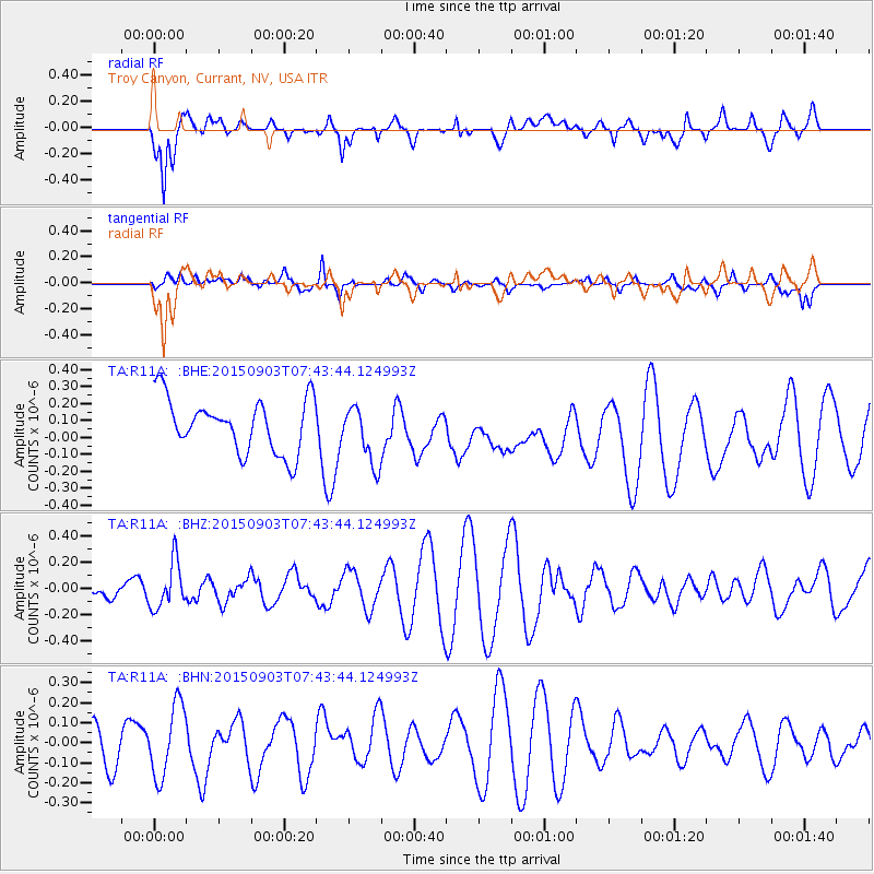
Signal To Noise
| Channel | StoN | STA | LTA |
| TA:R11A: :BHZ:20150903T07:43:44.124993Z | 2.210494 | 1.746536E-7 | 7.901111E-8 |
| TA:R11A: :BHN:20150903T07:43:44.124993Z | 1.440989 | 1.7955028E-7 | 1.2460211E-7 |
| TA:R11A: :BHE:20150903T07:43:44.124993Z | 1.1023853 | 1.7259677E-7 | 1.5656666E-7 |
| Arrivals |
| Ps | |
| PpPs | |
| PsPs/PpSs | |


