You are here: Home > Network List > TA - USArray Transportable Network (new EarthScope stations) Stations List
> Station M19K Big River Lodge, Big River, AK, USA > Earthquake Result Viewer
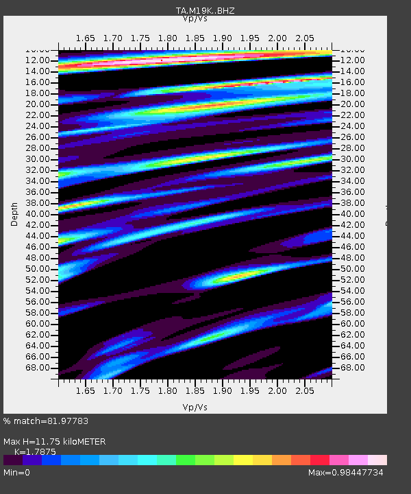
M19K Big River Lodge, Big River, AK, USA - Earthquake Result Viewer
| Earthquake location: |
Celebes Sea |
| Earthquake latitude/longitude: |
4.4/124.7 |
| Earthquake time(UTC): |
2015/09/02 (245) 01:18:30 GMT |
| Earthquake Depth: |
310 km |
| Earthquake Magnitude: |
5.9 MB |
| Earthquake Catalog/Contributor: |
NEIC PDE/NEIC COMCAT |
|
| Network: |
TA USArray Transportable Network (new EarthScope stations) |
| Station: |
M19K Big River Lodge, Big River, AK, USA |
| Lat/Lon: |
61.90 N/154.39 W |
| Elevation: |
521 m |
|
| Distance: |
81.9 deg |
| Az: |
28.176 deg |
| Baz: |
264.004 deg |
| Ray Param: |
0.046470843 |
| Estimated Moho Depth: |
11.75 km |
| Estimated Crust Vp/Vs: |
1.79 |
| Assumed Crust Vp: |
6.566 km/s |
| Estimated Crust Vs: |
3.673 km/s |
| Estimated Crust Poisson's Ratio: |
0.27 |
|
| Radial Match: |
81.97783 % |
| Radial Bump: |
400 |
| Transverse Match: |
66.00252 % |
| Transverse Bump: |
400 |
| SOD ConfigId: |
7422571 |
| Insert Time: |
2019-04-20 16:56:43.605 +0000 |
| GWidth: |
2.5 |
| Max Bumps: |
400 |
| Tol: |
0.001 |
|

Signal To Noise
| Channel | StoN | STA | LTA |
| TA:M19K: :BHZ:20150902T01:29:44.450Z | 15.910687 | 1.109215E-6 | 6.9715085E-8 |
| TA:M19K: :BHN:20150902T01:29:44.450Z | 2.1136515 | 2.0949125E-7 | 9.911343E-8 |
| TA:M19K: :BHE:20150902T01:29:44.450Z | 5.769018 | 5.4109387E-7 | 9.379306E-8 |
| Arrivals |
| Ps | 1.4 SECOND |
| PpPs | 4.9 SECOND |
| PsPs/PpSs | 6.3 SECOND |


