You are here: Home > Network List > TA - USArray Transportable Network (new EarthScope stations) Stations List
> Station H17A Grant Village (NPS), Yellowstone Nt. Park, WY, USA > Earthquake Result Viewer
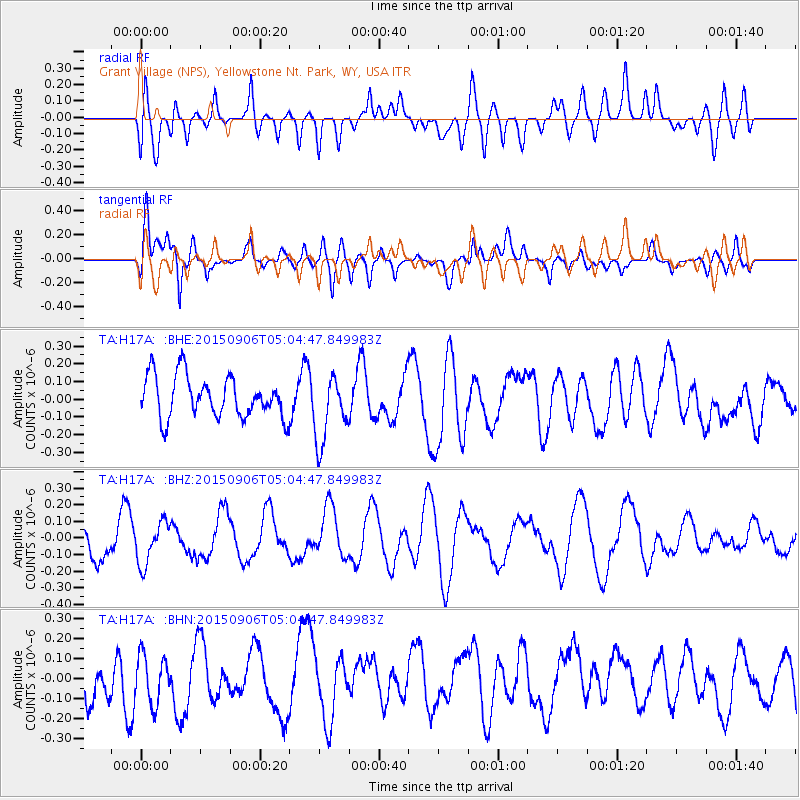
H17A Grant Village (NPS), Yellowstone Nt. Park, WY, USA - Earthquake Result Viewer
*The percent match for this event was below the threshold and hence no stack was calculated.
| Earthquake location: |
South Of Fiji Islands |
| Earthquake latitude/longitude: |
-25.0/179.9 |
| Earthquake time(UTC): |
2015/09/06 (249) 04:52:56 GMT |
| Earthquake Depth: |
508 km |
| Earthquake Magnitude: |
5.1 mb |
| Earthquake Catalog/Contributor: |
NEIC PDE/us |
|
| Network: |
TA USArray Transportable Network (new EarthScope stations) |
| Station: |
H17A Grant Village (NPS), Yellowstone Nt. Park, WY, USA |
| Lat/Lon: |
44.40 N/110.58 W |
| Elevation: |
2400 m |
|
| Distance: |
93.8 deg |
| Az: |
42.314 deg |
| Baz: |
238.415 deg |
| Ray Param: |
$rayparam |
*The percent match for this event was below the threshold and hence was not used in the summary stack. |
|
| Radial Match: |
38.844246 % |
| Radial Bump: |
400 |
| Transverse Match: |
43.381973 % |
| Transverse Bump: |
400 |
| SOD ConfigId: |
7422571 |
| Insert Time: |
2019-04-20 17:02:24.404 +0000 |
| GWidth: |
2.5 |
| Max Bumps: |
400 |
| Tol: |
0.001 |
|
Signal To Noise
| Channel | StoN | STA | LTA |
| TA:H17A: :BHZ:20150906T05:04:47.849983Z | 1.2857211 | 1.2554962E-7 | 9.764919E-8 |
| TA:H17A: :BHN:20150906T05:04:47.849983Z | 1.02449 | 1.195473E-7 | 1.1668958E-7 |
| TA:H17A: :BHE:20150906T05:04:47.849983Z | 1.6394075 | 1.9093896E-7 | 1.1646827E-7 |
| Arrivals |
| Ps | |
| PpPs | |
| PsPs/PpSs | |


