You are here: Home > Network List > IU - Global Seismograph Network (GSN - IRIS/USGS) Stations List
> Station NWAO Narrogin, Australia > Earthquake Result Viewer
NWAO Narrogin, Australia - Earthquake Result Viewer
| Earthquake location: |
Solomon Islands |
| Earthquake latitude/longitude: |
-7.3/154.5 |
| Earthquake time(UTC): |
2015/05/07 (127) 07:10:22 GMT |
| Earthquake Depth: |
22 km |
| Earthquake Magnitude: |
7.2 MWP, 7.2 MI |
| Earthquake Catalog/Contributor: |
NEIC PDE/NEIC COMCAT |
|
| Network: |
IU Global Seismograph Network (GSN - IRIS/USGS) |
| Station: |
NWAO Narrogin, Australia |
| Lat/Lon: |
32.93 S/117.24 E |
| Elevation: |
380 m |
|
| Distance: |
43.0 deg |
| Az: |
228.395 deg |
| Baz: |
61.887 deg |
| Ray Param: |
0.0728235 |
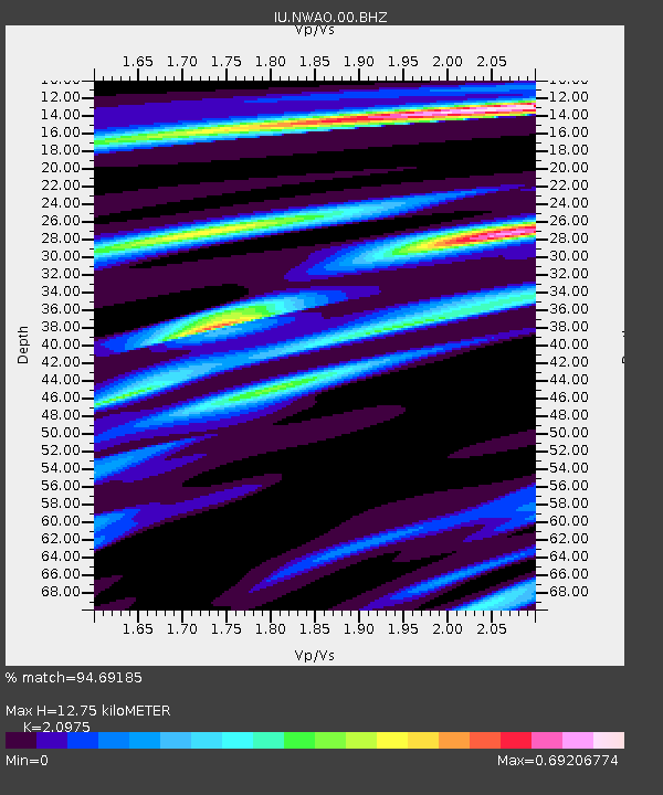
| Estimated Moho Depth: |
12.75 km |
| Estimated Crust Vp/Vs: |
2.10 |
| Assumed Crust Vp: |
6.419 km/s |
| Estimated Crust Vs: |
3.06 km/s |
| Estimated Crust Poisson's Ratio: |
0.35 |
|
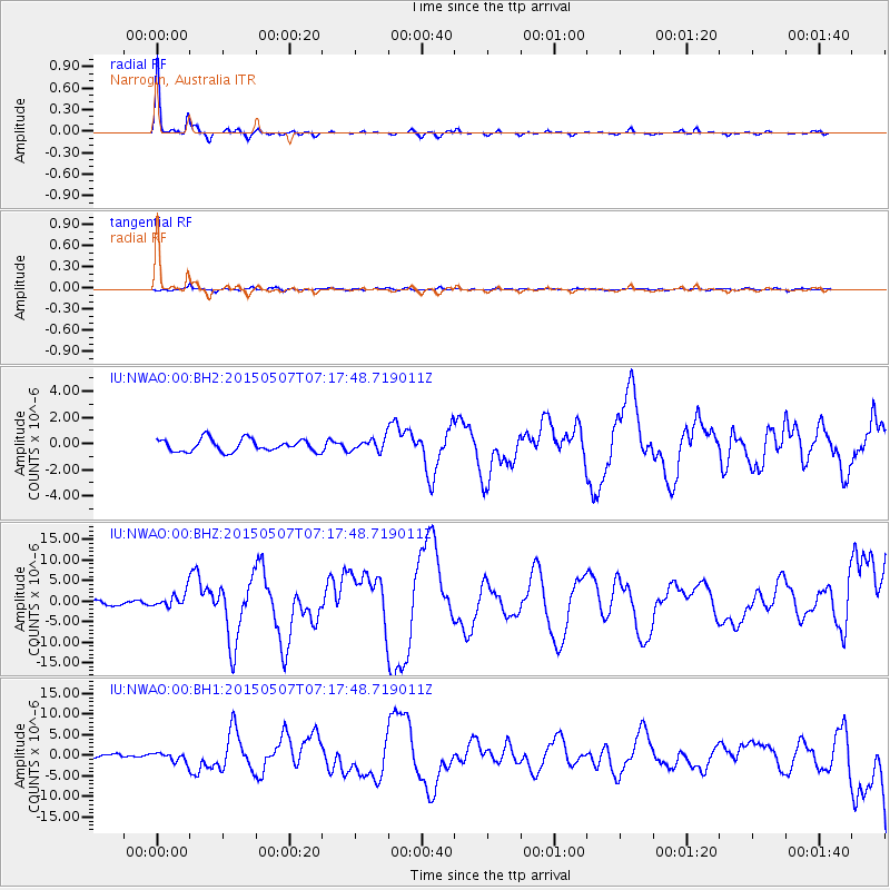
| Radial Match: |
94.69185 % |
| Radial Bump: |
200 |
| Transverse Match: |
77.35757 % |
| Transverse Bump: |
400 |
| SOD ConfigId: |
872571 |
| Insert Time: |
2015-05-21 11:29:29.661 +0000 |
| GWidth: |
2.5 |
| Max Bumps: |
400 |
| Tol: |
0.001 |
|
Signal To Noise
| Channel | StoN | STA | LTA |
| IU:NWAO:00:BHZ:20150507T07:17:48.719011Z | 3.6292515 | 1.8166697E-6 | 5.005632E-7 |
| IU:NWAO:00:BH1:20150507T07:17:48.719011Z | 1.9080093 | 1.1460407E-6 | 6.006474E-7 |
| IU:NWAO:00:BH2:20150507T07:17:48.719011Z | 0.99405766 | 4.6951007E-7 | 4.7231674E-7 |
| Arrivals |
| Ps | 2.3 SECOND |
| PpPs | 5.8 SECOND |
| PsPs/PpSs | 8.1 SECOND |


