You are here: Home > Network List > AV - Alaska Volcano Observatory Stations List
> Station MAPS Pakushin Southeast, Makushin Volcano, Alaska > Earthquake Result Viewer
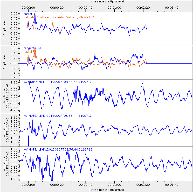
MAPS Pakushin Southeast, Makushin Volcano, Alaska - Earthquake Result Viewer
*The percent match for this event was below the threshold and hence no stack was calculated.
| Earthquake location: |
South Of Fiji Islands |
| Earthquake latitude/longitude: |
-24.2/179.1 |
| Earthquake time(UTC): |
2015/09/07 (250) 08:46:09 GMT |
| Earthquake Depth: |
535 km |
| Earthquake Magnitude: |
6.0 mww |
| Earthquake Catalog/Contributor: |
NEIC PDE/us |
|
| Network: |
AV Alaska Volcano Observatory |
| Station: |
MAPS Pakushin Southeast, Makushin Volcano, Alaska |
| Lat/Lon: |
53.81 N/166.94 W |
| Elevation: |
333 m |
|
| Distance: |
78.7 deg |
| Az: |
8.374 deg |
| Baz: |
192.953 deg |
| Ray Param: |
$rayparam |
*The percent match for this event was below the threshold and hence was not used in the summary stack. |
|
| Radial Match: |
77.75018 % |
| Radial Bump: |
400 |
| Transverse Match: |
52.088707 % |
| Transverse Bump: |
400 |
| SOD ConfigId: |
7422571 |
| Insert Time: |
2019-04-20 17:05:56.348 +0000 |
| GWidth: |
2.5 |
| Max Bumps: |
400 |
| Tol: |
0.001 |
|
Signal To Noise
| Channel | StoN | STA | LTA |
| AV:MAPS: :BHZ:20150907T08:56:44.519971Z | 2.2570276 | 6.1219913E-7 | 2.712413E-7 |
| AV:MAPS: :BHN:20150907T08:56:44.519971Z | 0.7739313 | 2.8727266E-7 | 3.7118625E-7 |
| AV:MAPS: :BHE:20150907T08:56:44.519971Z | 0.8462633 | 5.3474264E-7 | 6.3188685E-7 |
| Arrivals |
| Ps | |
| PpPs | |
| PsPs/PpSs | |


