You are here: Home > Network List > CI - Caltech Regional Seismic Network Stations List
> Station GSC Goldstone, Goldstone Lake, CA, USA > Earthquake Result Viewer
GSC Goldstone, Goldstone Lake, CA, USA - Earthquake Result Viewer
| Earthquake location: |
Near Coast Of Central Chile |
| Earthquake latitude/longitude: |
-29.7/-71.4 |
| Earthquake time(UTC): |
2002/04/01 (091) 19:59:32 GMT |
| Earthquake Depth: |
71 km |
| Earthquake Magnitude: |
6.1 MB, 6.4 MW, 6.4 MW |
| Earthquake Catalog/Contributor: |
WHDF/NEIC |
|
| Network: |
CI Caltech Regional Seismic Network |
| Station: |
GSC Goldstone, Goldstone Lake, CA, USA |
| Lat/Lon: |
35.30 N/116.81 W |
| Elevation: |
1000 m |
|
| Distance: |
77.5 deg |
| Az: |
323.363 deg |
| Baz: |
140.584 deg |
| Ray Param: |
0.05012593 |
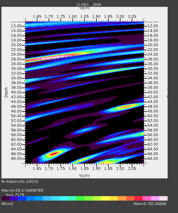
| Estimated Moho Depth: |
25.0 km |
| Estimated Crust Vp/Vs: |
1.72 |
| Assumed Crust Vp: |
6.276 km/s |
| Estimated Crust Vs: |
3.654 km/s |
| Estimated Crust Poisson's Ratio: |
0.24 |
|
| Radial Match: |
91.03033 % |
| Radial Bump: |
400 |
| Transverse Match: |
84.49911 % |
| Transverse Bump: |
400 |
| SOD ConfigId: |
3787 |
| Insert Time: |
2010-02-25 23:41:53.700 +0000 |
| GWidth: |
2.5 |
| Max Bumps: |
400 |
| Tol: |
0.001 |
|
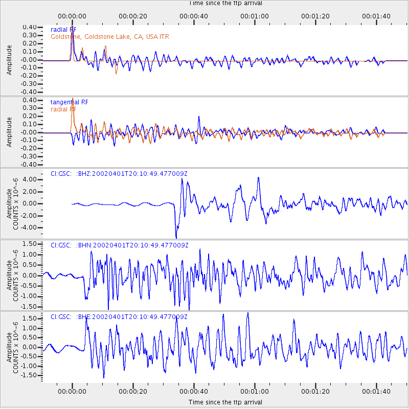
Signal To Noise
| Channel | StoN | STA | LTA |
| CI:GSC: :BHN:20020401T20:10:49.477009Z | 4.466063 | 3.9135432E-7 | 8.762848E-8 |
| CI:GSC: :BHE:20020401T20:10:49.477009Z | 2.8617427 | 4.5955053E-7 | 1.6058416E-7 |
| CI:GSC: :BHZ:20020401T20:10:49.477009Z | 11.928611 | 1.8684051E-6 | 1.5663224E-7 |
| Arrivals |
| Ps | 2.9 SECOND |
| PpPs | 11 SECOND |
| PsPs/PpSs | 13 SECOND |


