You are here: Home > Network List > IU - Global Seismograph Network (GSN - IRIS/USGS) Stations List
> Station CHTO Chiang Mai, Thailand > Earthquake Result Viewer
CHTO Chiang Mai, Thailand - Earthquake Result Viewer
| Earthquake location: |
Kuril Islands |
| Earthquake latitude/longitude: |
45.3/149.9 |
| Earthquake time(UTC): |
1996/02/07 (038) 21:36:45 GMT |
| Earthquake Depth: |
33 km |
| Earthquake Magnitude: |
6.3 MB, 7.0 MS, 7.2 UNKNOWN, 7.1 MW |
| Earthquake Catalog/Contributor: |
WHDF/NEIC |
|
| Network: |
IU Global Seismograph Network (GSN - IRIS/USGS) |
| Station: |
CHTO Chiang Mai, Thailand |
| Lat/Lon: |
18.79 N/98.98 E |
| Elevation: |
316 m |
|
| Distance: |
49.6 deg |
| Az: |
254.988 deg |
| Baz: |
45.997 deg |
| Ray Param: |
0.068536125 |
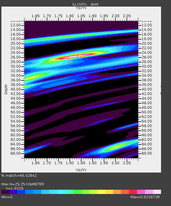
| Estimated Moho Depth: |
25.25 km |
| Estimated Crust Vp/Vs: |
1.83 |
| Assumed Crust Vp: |
6.35 km/s |
| Estimated Crust Vs: |
3.465 km/s |
| Estimated Crust Poisson's Ratio: |
0.29 |
|
| Radial Match: |
98.42942 % |
| Radial Bump: |
255 |
| Transverse Match: |
88.83466 % |
| Transverse Bump: |
400 |
| SOD ConfigId: |
6273 |
| Insert Time: |
2010-03-04 19:13:43.144 +0000 |
| GWidth: |
2.5 |
| Max Bumps: |
400 |
| Tol: |
0.001 |
|
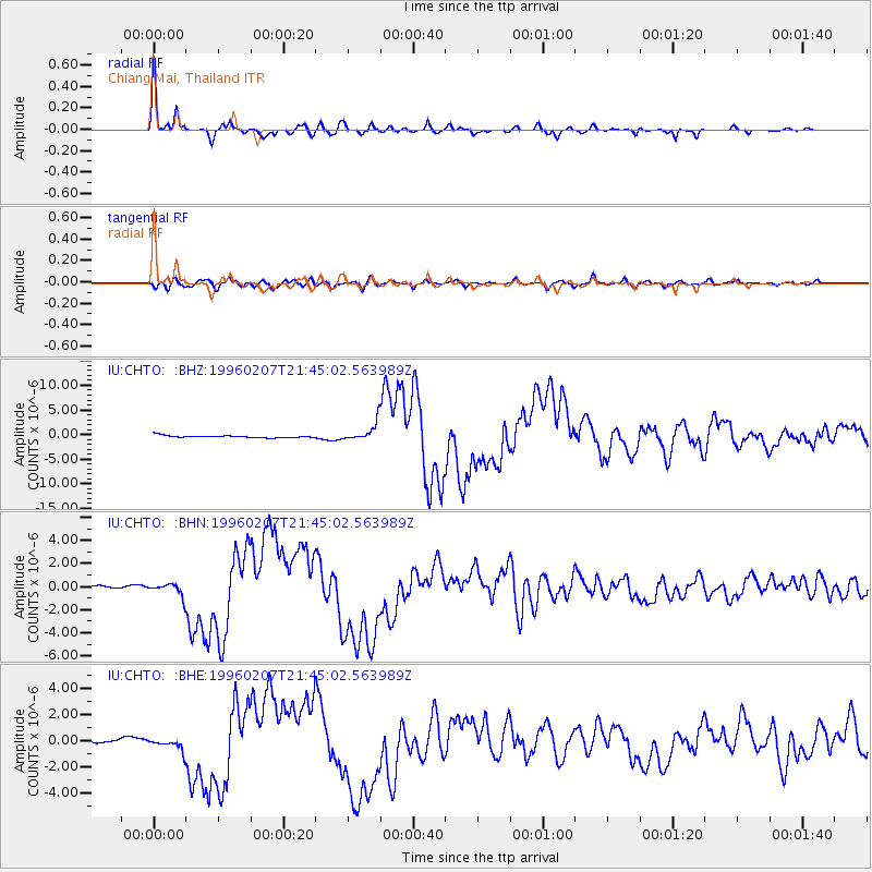
Signal To Noise
| Channel | StoN | STA | LTA |
| IU:CHTO: :BHN:19960207T21:45:02.563989Z | 3.5638404 | 5.768977E-7 | 1.6187529E-7 |
| IU:CHTO: :BHE:19960207T21:45:02.563989Z | 2.6996853 | 5.038415E-7 | 1.8662972E-7 |
| IU:CHTO: :BHZ:19960207T21:45:02.563989Z | 8.125236 | 1.8617551E-6 | 2.2913245E-7 |
| Arrivals |
| Ps | 3.5 SECOND |
| PpPs | 11 SECOND |
| PsPs/PpSs | 14 SECOND |


