You are here: Home > Network List > US - United States National Seismic Network Stations List
> Station WRAK Wrangell Island, Southeastern Alaska, Alaska, USA > Earthquake Result Viewer
WRAK Wrangell Island, Southeastern Alaska, Alaska, USA - Earthquake Result Viewer
| Earthquake location: |
Solomon Islands |
| Earthquake latitude/longitude: |
-7.3/154.5 |
| Earthquake time(UTC): |
2015/05/07 (127) 07:10:22 GMT |
| Earthquake Depth: |
22 km |
| Earthquake Magnitude: |
7.2 MWP, 7.2 MI |
| Earthquake Catalog/Contributor: |
NEIC PDE/NEIC COMCAT |
|
| Network: |
US United States National Seismic Network |
| Station: |
WRAK Wrangell Island, Southeastern Alaska, Alaska, USA |
| Lat/Lon: |
56.42 N/132.35 W |
| Elevation: |
81 m |
|
| Distance: |
86.8 deg |
| Az: |
32.179 deg |
| Baz: |
251.946 deg |
| Ray Param: |
0.0437514 |
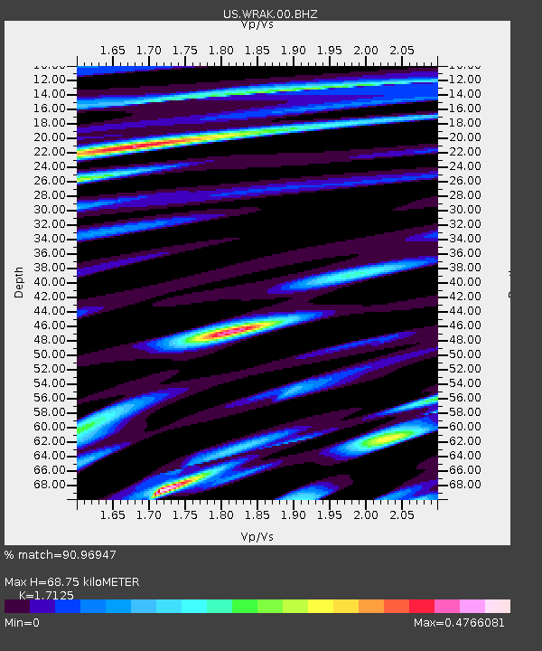
| Estimated Moho Depth: |
68.75 km |
| Estimated Crust Vp/Vs: |
1.71 |
| Assumed Crust Vp: |
6.597 km/s |
| Estimated Crust Vs: |
3.853 km/s |
| Estimated Crust Poisson's Ratio: |
0.24 |
|
| Radial Match: |
90.96947 % |
| Radial Bump: |
400 |
| Transverse Match: |
91.12303 % |
| Transverse Bump: |
400 |
| SOD ConfigId: |
872571 |
| Insert Time: |
2015-05-21 11:31:34.147 +0000 |
| GWidth: |
2.5 |
| Max Bumps: |
400 |
| Tol: |
0.001 |
|
Signal To Noise
| Channel | StoN | STA | LTA |
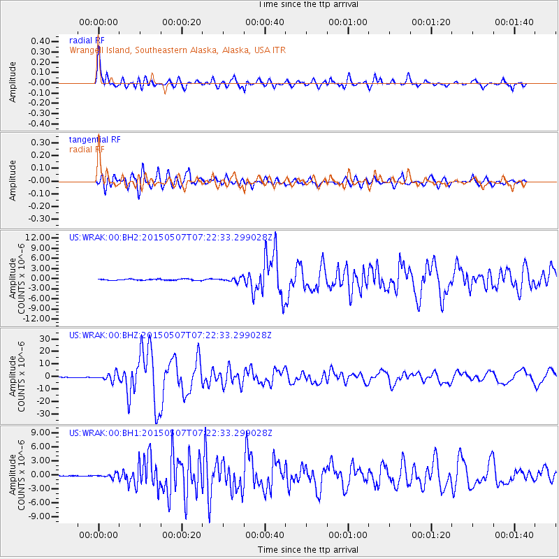
| US:WRAK:00:BHZ:20150507T07:22:33.299028Z | 22.039158 | 3.0373415E-6 | 1.3781568E-7 |
| US:WRAK:00:BH1:20150507T07:22:33.299028Z | 3.7328582 | 4.270941E-7 | 1.14414775E-7 |
| US:WRAK:00:BH2:20150507T07:22:33.299028Z | 3.334744 | 6.2013163E-7 | 1.8596079E-7 |
| Arrivals |
| Ps | 7.6 SECOND |
| PpPs | 28 SECOND |
| PsPs/PpSs | 35 SECOND |


