You are here: Home > Network List > YT07 - POLENET Stations List
> Station THUR THUR > Earthquake Result Viewer
THUR THUR - Earthquake Result Viewer
| Earthquake location: |
South Of Kermadec Islands |
| Earthquake latitude/longitude: |
-32.9/-177.9 |
| Earthquake time(UTC): |
2015/09/07 (250) 09:13:58 GMT |
| Earthquake Depth: |
35 km |
| Earthquake Magnitude: |
6.4 MWP |
| Earthquake Catalog/Contributor: |
NEIC PDE/NEIC COMCAT |
|
| Network: |
YT POLENET |
| Station: |
THUR THUR |
| Lat/Lon: |
72.53 S/97.56 W |
| Elevation: |
239 m |
|
| Distance: |
56.0 deg |
| Az: |
158.965 deg |
| Baz: |
268.012 deg |
| Ray Param: |
0.06432877 |
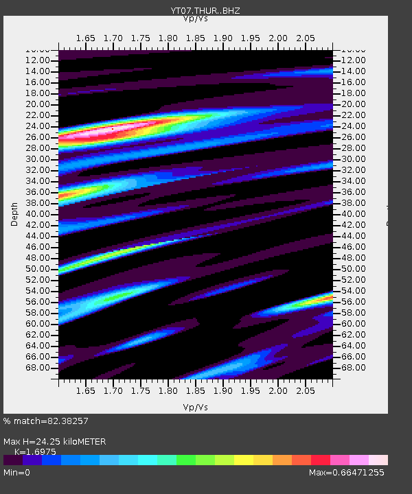
| Estimated Moho Depth: |
24.25 km |
| Estimated Crust Vp/Vs: |
1.70 |
| Assumed Crust Vp: |
6.43 km/s |
| Estimated Crust Vs: |
3.788 km/s |
| Estimated Crust Poisson's Ratio: |
0.23 |
|
| Radial Match: |
82.38257 % |
| Radial Bump: |
400 |
| Transverse Match: |
70.65527 % |
| Transverse Bump: |
400 |
| SOD ConfigId: |
7422571 |
| Insert Time: |
2019-04-20 17:17:16.597 +0000 |
| GWidth: |
2.5 |
| Max Bumps: |
400 |
| Tol: |
0.001 |
|

Signal To Noise
| Channel | StoN | STA | LTA |
| YT:THUR: :BHZ:20150907T09:23:04.124995Z | 2.8948479 | 2.821775E-7 | 9.747576E-8 |
| YT:THUR: :BHN:20150907T09:23:04.124995Z | 1.3121568 | 1.5026308E-7 | 1.145161E-7 |
| YT:THUR: :BHE:20150907T09:23:04.124995Z | 2.360024 | 2.441358E-7 | 1.0344633E-7 |
| Arrivals |
| Ps | 2.8 SECOND |
| PpPs | 9.6 SECOND |
| PsPs/PpSs | 12 SECOND |


