You are here: Home > Network List > YT07 - POLENET Stations List
> Station WAWA WAWA > Earthquake Result Viewer
WAWA WAWA - Earthquake Result Viewer
| Earthquake location: |
South Of Kermadec Islands |
| Earthquake latitude/longitude: |
-32.9/-177.9 |
| Earthquake time(UTC): |
2015/09/07 (250) 09:13:58 GMT |
| Earthquake Depth: |
35 km |
| Earthquake Magnitude: |
6.4 MWP |
| Earthquake Catalog/Contributor: |
NEIC PDE/NEIC COMCAT |
|
| Network: |
YT POLENET |
| Station: |
WAWA WAWA |
| Lat/Lon: |
81.58 S/28.42 W |
| Elevation: |
1202 m |
|
| Distance: |
64.6 deg |
| Az: |
175.246 deg |
| Baz: |
208.215 deg |
| Ray Param: |
0.058737256 |
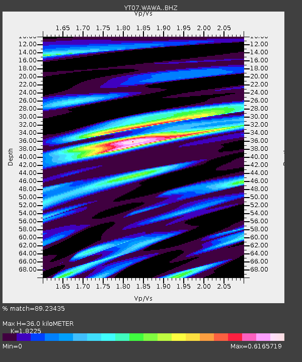
| Estimated Moho Depth: |
36.0 km |
| Estimated Crust Vp/Vs: |
1.82 |
| Assumed Crust Vp: |
6.424 km/s |
| Estimated Crust Vs: |
3.525 km/s |
| Estimated Crust Poisson's Ratio: |
0.28 |
|
| Radial Match: |
89.23435 % |
| Radial Bump: |
400 |
| Transverse Match: |
79.15041 % |
| Transverse Bump: |
400 |
| SOD ConfigId: |
7422571 |
| Insert Time: |
2019-04-20 17:17:17.679 +0000 |
| GWidth: |
2.5 |
| Max Bumps: |
400 |
| Tol: |
0.001 |
|

Signal To Noise
| Channel | StoN | STA | LTA |
| YT:WAWA: :BHZ:20150907T09:24:02.77502Z | 1.9038327 | 1.9978134E-7 | 1.0493639E-7 |
| YT:WAWA: :BHN:20150907T09:24:02.77502Z | 1.402404 | 1.7659501E-7 | 1.2592307E-7 |
| YT:WAWA: :BHE:20150907T09:24:02.77502Z | 1.782541 | 1.3109576E-7 | 7.354431E-8 |
| Arrivals |
| Ps | 4.8 SECOND |
| PpPs | 15 SECOND |
| PsPs/PpSs | 20 SECOND |


