You are here: Home > Network List > ZJ12 - Transantarctic Mountains Northern Network Stations List
> Station SAMH East Antarctica > Earthquake Result Viewer
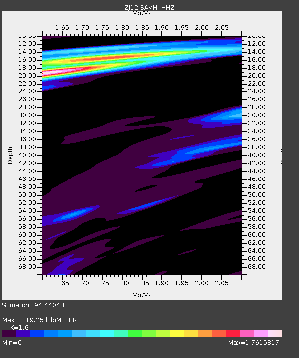
SAMH East Antarctica - Earthquake Result Viewer
| Earthquake location: |
South Of Kermadec Islands |
| Earthquake latitude/longitude: |
-32.9/-177.9 |
| Earthquake time(UTC): |
2015/09/07 (250) 09:13:58 GMT |
| Earthquake Depth: |
35 km |
| Earthquake Magnitude: |
6.4 MWP |
| Earthquake Catalog/Contributor: |
NEIC PDE/NEIC COMCAT |
|
| Network: |
ZJ Transantarctic Mountains Northern Network |
| Station: |
SAMH East Antarctica |
| Lat/Lon: |
75.20 S/154.00 E |
| Elevation: |
2087 m |
|
| Distance: |
44.5 deg |
| Az: |
189.953 deg |
| Baz: |
34.444 deg |
| Ray Param: |
0.07182142 |
| Estimated Moho Depth: |
19.25 km |
| Estimated Crust Vp/Vs: |
1.60 |
| Assumed Crust Vp: |
6.262 km/s |
| Estimated Crust Vs: |
3.914 km/s |
| Estimated Crust Poisson's Ratio: |
0.18 |
|
| Radial Match: |
94.44043 % |
| Radial Bump: |
400 |
| Transverse Match: |
78.923904 % |
| Transverse Bump: |
400 |
| SOD ConfigId: |
7422571 |
| Insert Time: |
2019-04-20 17:17:24.472 +0000 |
| GWidth: |
2.5 |
| Max Bumps: |
400 |
| Tol: |
0.001 |
|

Signal To Noise
| Channel | StoN | STA | LTA |
| ZJ:SAMH: :HHZ:20150907T09:21:36.86999Z | 2.3110187 | 3.3998094E-7 | 1.4711303E-7 |
| ZJ:SAMH: :HHN:20150907T09:21:36.86999Z | 0.6800374 | 1.0315468E-7 | 1.5168973E-7 |
| ZJ:SAMH: :HHE:20150907T09:21:36.86999Z | 0.99105436 | 1.546909E-7 | 1.560872E-7 |
| Arrivals |
| Ps | 2.0 SECOND |
| PpPs | 7.5 SECOND |
| PsPs/PpSs | 9.4 SECOND |


