You are here: Home > Network List > AU - Australian Seismological Centre Stations List
> Station CTA Charters Towers, Queensland > Earthquake Result Viewer
CTA Charters Towers, Queensland - Earthquake Result Viewer
| Earthquake location: |
South Of Kermadec Islands |
| Earthquake latitude/longitude: |
-32.8/-178.2 |
| Earthquake time(UTC): |
2015/09/07 (250) 14:06:27 GMT |
| Earthquake Depth: |
8.3 km |
| Earthquake Magnitude: |
5.9 MWW, 5.9 MWB, 5.9 MWC |
| Earthquake Catalog/Contributor: |
NEIC PDE/NEIC COMCAT |
|
| Network: |
AU Australian Seismological Centre |
| Station: |
CTA Charters Towers, Queensland |
| Lat/Lon: |
20.09 S/146.25 E |
| Elevation: |
426 m |
|
| Distance: |
34.1 deg |
| Az: |
282.881 deg |
| Baz: |
119.16 deg |
| Ray Param: |
0.07790104 |
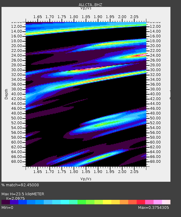
| Estimated Moho Depth: |
23.5 km |
| Estimated Crust Vp/Vs: |
2.10 |
| Assumed Crust Vp: |
6.522 km/s |
| Estimated Crust Vs: |
3.109 km/s |
| Estimated Crust Poisson's Ratio: |
0.35 |
|
| Radial Match: |
92.45008 % |
| Radial Bump: |
244 |
| Transverse Match: |
64.662415 % |
| Transverse Bump: |
400 |
| SOD ConfigId: |
7422571 |
| Insert Time: |
2019-04-20 17:19:05.595 +0000 |
| GWidth: |
2.5 |
| Max Bumps: |
400 |
| Tol: |
0.001 |
|

Signal To Noise
| Channel | StoN | STA | LTA |
| AU:CTA: :BHZ:20150907T14:12:41.750011Z | 4.1255493 | 9.1924784E-7 | 2.2281829E-7 |
| AU:CTA: :BHN:20150907T14:12:41.750011Z | 1.3347484 | 2.3052765E-7 | 1.7271243E-7 |
| AU:CTA: :BHE:20150907T14:12:41.750011Z | 3.2959676 | 5.433395E-7 | 1.6484978E-7 |
| Arrivals |
| Ps | 4.2 SECOND |
| PpPs | 10 SECOND |
| PsPs/PpSs | 15 SECOND |


