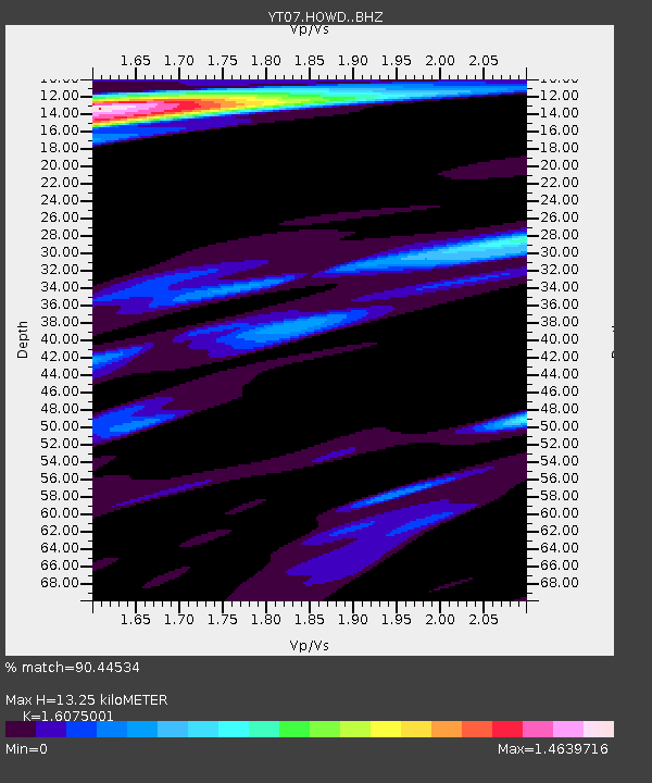
HOWD HOWD - Earthquake Result Viewer

Earthquake location: South Of Kermadec Islands
Earthquake latitude/longitude: -32.8/-178.2
Earthquake time(UTC): 2015/09/07 (250) 14:06:27 GMT
Earthquake Depth: 8.3 km
Earthquake Magnitude: 5.9 MWW, 5.9 MWB, 5.9 MWC
Earthquake Catalog/Contributor: NEIC PDE/NEIC COMCAT
Network: YT POLENET
Station: HOWD HOWD
Lat/Lon: 77.53 S/86.77 W
Elevation: 1495 m
Distance: 58.5 deg
Az: 165.241 deg
Baz: 260.719 deg
Ray Param: 0.06279049
Estimated Moho Depth: 13.25 km
Estimated Crust Vp/Vs: 1.61
Assumed Crust Vp: 6.047 km/s
Estimated Crust Vs: 3.762 km/s
Estimated Crust Poisson's Ratio: 0.18
Radial Match: 90.44534 %
Radial Bump: 376
Transverse Match: 61.40876 %
Transverse Bump: 400
SOD ConfigId: 7422571
Insert Time: 2019-04-20 17:23:25.068 +0000
GWidth: 2.5
Max Bumps: 400
Tol: 0.001

Signal To Noise

ChannelStoNSTALTA
YT:HOWD: :BHZ:20150907T14:15:53.199993Z7.12244754.3643286E-76.1275685E-8
YT:HOWD: :BHN:20150907T14:15:53.199993Z0.785104931.18474766E-71.509031E-7
YT:HOWD: :BHE:20150907T14:15:53.199993Z1.3537431.2186996E-79.002444E-8
Arrivals
Ps1.4 SECOND
PpPs5.4 SECOND
PsPs/PpSs6.8 SECOND