You are here: Home > Network List > ZJ12 - Transantarctic Mountains Northern Network Stations List
> Station MICH Tinker Glacier, Antarctica > Earthquake Result Viewer
MICH Tinker Glacier, Antarctica - Earthquake Result Viewer
| Earthquake location: |
South Of Kermadec Islands |
| Earthquake latitude/longitude: |
-33.0/-178.5 |
| Earthquake time(UTC): |
2015/09/08 (251) 06:48:33 GMT |
| Earthquake Depth: |
10 km |
| Earthquake Magnitude: |
5.6 MB |
| Earthquake Catalog/Contributor: |
NEIC PDE/NEIC COMCAT |
|
| Network: |
ZJ Transantarctic Mountains Northern Network |
| Station: |
MICH Tinker Glacier, Antarctica |
| Lat/Lon: |
73.82 S/164.10 E |
| Elevation: |
817 m |
|
| Distance: |
41.8 deg |
| Az: |
187.212 deg |
| Baz: |
22.089 deg |
| Ray Param: |
0.07357439 |
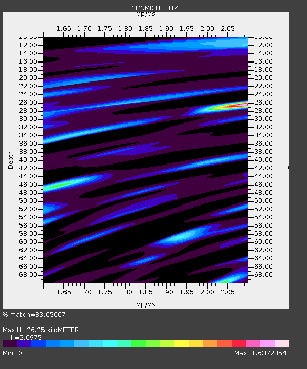
| Estimated Moho Depth: |
26.25 km |
| Estimated Crust Vp/Vs: |
2.10 |
| Assumed Crust Vp: |
6.245 km/s |
| Estimated Crust Vs: |
2.977 km/s |
| Estimated Crust Poisson's Ratio: |
0.35 |
|
| Radial Match: |
83.05007 % |
| Radial Bump: |
400 |
| Transverse Match: |
76.33968 % |
| Transverse Bump: |
400 |
| SOD ConfigId: |
7422571 |
| Insert Time: |
2019-04-20 17:29:22.352 +0000 |
| GWidth: |
2.5 |
| Max Bumps: |
400 |
| Tol: |
0.001 |
|

Signal To Noise
| Channel | StoN | STA | LTA |
| ZJ:MICH: :HHZ:20150908T06:55:51.568988Z | 4.0317464 | 3.9177004E-7 | 9.71713E-8 |
| ZJ:MICH: :HHN:20150908T06:55:51.568988Z | 1.4018545 | 2.0239264E-7 | 1.4437492E-7 |
| ZJ:MICH: :HHE:20150908T06:55:51.568988Z | 1.4939414 | 1.2702715E-7 | 8.50282E-8 |
| Arrivals |
| Ps | 4.9 SECOND |
| PpPs | 12 SECOND |
| PsPs/PpSs | 17 SECOND |


