You are here: Home > Network List > CI - Caltech Regional Seismic Network Stations List
> Station GSC Goldstone, Goldstone Lake, CA, USA > Earthquake Result Viewer
GSC Goldstone, Goldstone Lake, CA, USA - Earthquake Result Viewer
| Earthquake location: |
Dominican Republic Region |
| Earthquake latitude/longitude: |
19.8/-70.7 |
| Earthquake time(UTC): |
2003/09/22 (265) 04:45:36 GMT |
| Earthquake Depth: |
10 km |
| Earthquake Magnitude: |
6.2 MB, 6.6 MS, 6.5 MW, 6.4 MW |
| Earthquake Catalog/Contributor: |
WHDF/NEIC |
|
| Network: |
CI Caltech Regional Seismic Network |
| Station: |
GSC Goldstone, Goldstone Lake, CA, USA |
| Lat/Lon: |
35.30 N/116.81 W |
| Elevation: |
1000 m |
|
| Distance: |
43.3 deg |
| Az: |
300.771 deg |
| Baz: |
98.406 deg |
| Ray Param: |
0.072616056 |
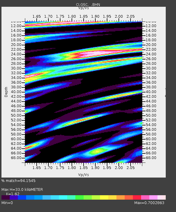
| Estimated Moho Depth: |
33.0 km |
| Estimated Crust Vp/Vs: |
1.62 |
| Assumed Crust Vp: |
6.276 km/s |
| Estimated Crust Vs: |
3.874 km/s |
| Estimated Crust Poisson's Ratio: |
0.19 |
|
| Radial Match: |
94.1545 % |
| Radial Bump: |
317 |
| Transverse Match: |
79.54 % |
| Transverse Bump: |
400 |
| SOD ConfigId: |
3787 |
| Insert Time: |
2010-02-25 23:42:13.825 +0000 |
| GWidth: |
2.5 |
| Max Bumps: |
400 |
| Tol: |
0.001 |
|
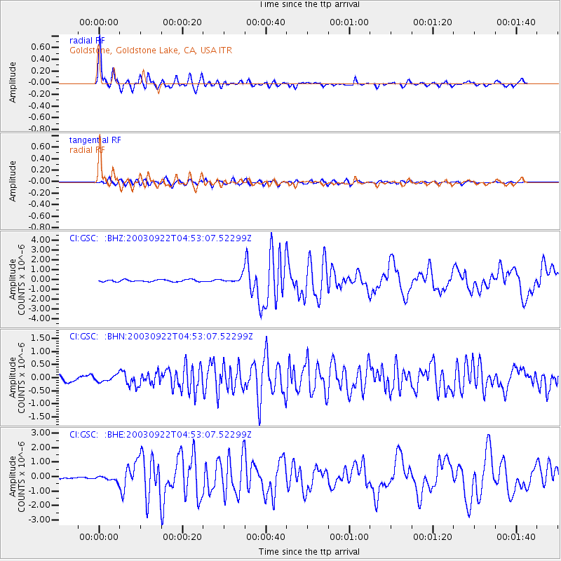
Signal To Noise
| Channel | StoN | STA | LTA |
| CI:GSC: :BHN:20030922T04:53:07.52299Z | 1.2601453 | 1.2353902E-7 | 9.8035535E-8 |
| CI:GSC: :BHE:20030922T04:53:07.52299Z | 1.8330231 | 1.7804035E-7 | 9.712935E-8 |
| CI:GSC: :BHZ:20030922T04:53:07.52299Z | 3.5678897 | 3.5869937E-7 | 1.0053544E-7 |
| Arrivals |
| Ps | 3.5 SECOND |
| PpPs | 13 SECOND |
| PsPs/PpSs | 16 SECOND |


