You are here: Home > Network List > TA - USArray Transportable Network (new EarthScope stations) Stations List
> Station G03D McMinnville, OR, USA > Earthquake Result Viewer
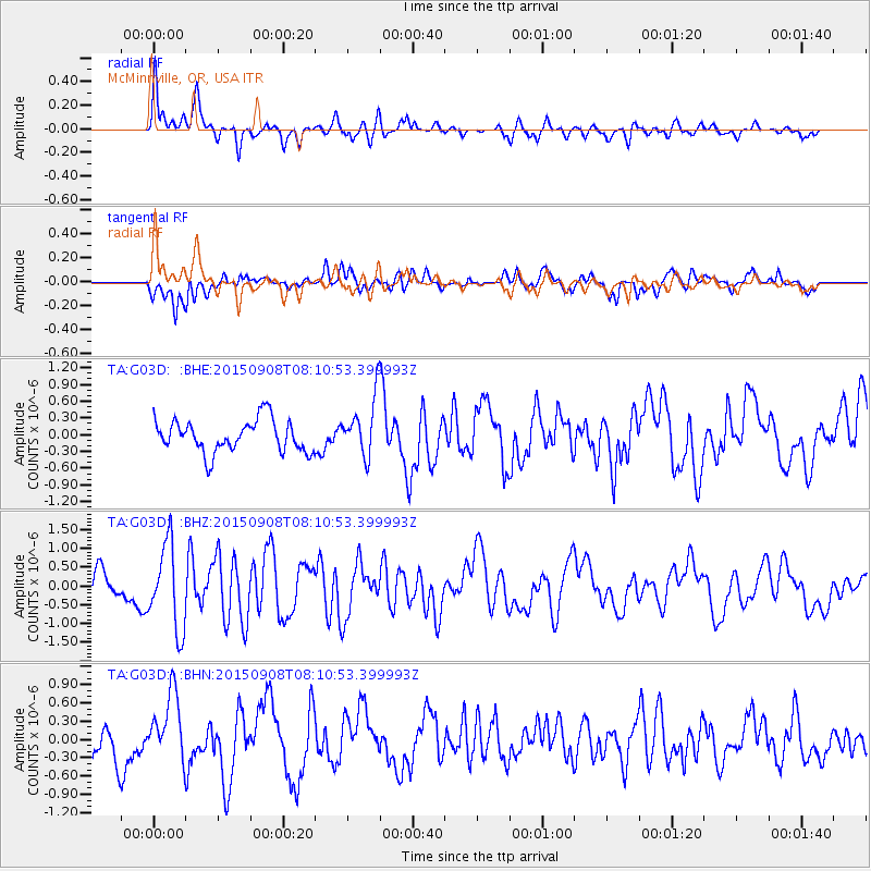
G03D McMinnville, OR, USA - Earthquake Result Viewer
*The percent match for this event was below the threshold and hence no stack was calculated.
| Earthquake location: |
Near Coast Of Chiapas, Mexico |
| Earthquake latitude/longitude: |
14.7/-93.9 |
| Earthquake time(UTC): |
2015/09/08 (251) 08:03:54 GMT |
| Earthquake Depth: |
4.1 km |
| Earthquake Magnitude: |
5.5 MB, 5.7 MWB |
| Earthquake Catalog/Contributor: |
NEIC PDE/NEIC COMCAT |
|
| Network: |
TA USArray Transportable Network (new EarthScope stations) |
| Station: |
G03D McMinnville, OR, USA |
| Lat/Lon: |
45.21 N/123.26 W |
| Elevation: |
222 m |
|
| Distance: |
39.3 deg |
| Az: |
326.782 deg |
| Baz: |
131.404 deg |
| Ray Param: |
$rayparam |
*The percent match for this event was below the threshold and hence was not used in the summary stack. |
|
| Radial Match: |
74.46579 % |
| Radial Bump: |
400 |
| Transverse Match: |
73.969475 % |
| Transverse Bump: |
400 |
| SOD ConfigId: |
7422571 |
| Insert Time: |
2019-04-20 17:35:33.447 +0000 |
| GWidth: |
2.5 |
| Max Bumps: |
400 |
| Tol: |
0.001 |
|
Signal To Noise
| Channel | StoN | STA | LTA |
| TA:G03D: :BHZ:20150908T08:10:53.399993Z | 3.4708252 | 1.1289188E-6 | 3.252595E-7 |
| TA:G03D: :BHN:20150908T08:10:53.399993Z | 1.2374557 | 5.356027E-7 | 4.3282571E-7 |
| TA:G03D: :BHE:20150908T08:10:53.399993Z | 2.0266528 | 5.835982E-7 | 2.8796163E-7 |
| Arrivals |
| Ps | |
| PpPs | |
| PsPs/PpSs | |


