You are here: Home > Network List > UW - Pacific Northwest Regional Seismic Network Stations List
> Station LEBA Lebam, WA, USA > Earthquake Result Viewer
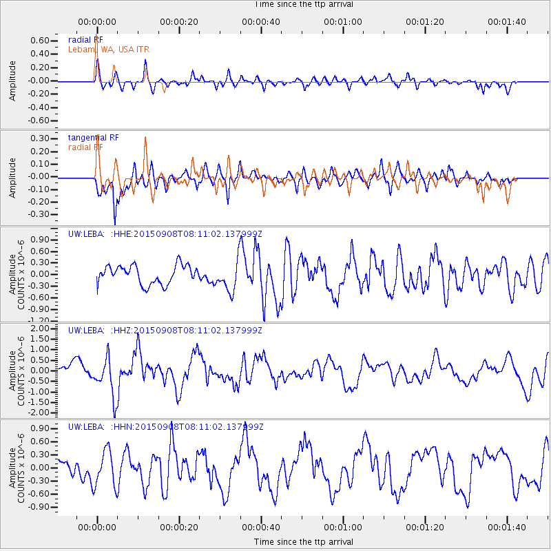
LEBA Lebam, WA, USA - Earthquake Result Viewer
*The percent match for this event was below the threshold and hence no stack was calculated.
| Earthquake location: |
Near Coast Of Chiapas, Mexico |
| Earthquake latitude/longitude: |
14.7/-93.9 |
| Earthquake time(UTC): |
2015/09/08 (251) 08:03:54 GMT |
| Earthquake Depth: |
4.1 km |
| Earthquake Magnitude: |
5.5 MB, 5.7 MWB |
| Earthquake Catalog/Contributor: |
NEIC PDE/NEIC COMCAT |
|
| Network: |
UW Pacific Northwest Regional Seismic Network |
| Station: |
LEBA Lebam, WA, USA |
| Lat/Lon: |
46.55 N/123.56 W |
| Elevation: |
73 m |
|
| Distance: |
40.3 deg |
| Az: |
328.119 deg |
| Baz: |
132.217 deg |
| Ray Param: |
$rayparam |
*The percent match for this event was below the threshold and hence was not used in the summary stack. |
|
| Radial Match: |
59.354713 % |
| Radial Bump: |
400 |
| Transverse Match: |
77.62907 % |
| Transverse Bump: |
400 |
| SOD ConfigId: |
7422571 |
| Insert Time: |
2019-04-20 17:36:46.439 +0000 |
| GWidth: |
2.5 |
| Max Bumps: |
400 |
| Tol: |
0.001 |
|
Signal To Noise
| Channel | StoN | STA | LTA |
| UW:LEBA: :HHZ:20150908T08:11:02.137999Z | 2.3670053 | 9.656469E-7 | 4.0796147E-7 |
| UW:LEBA: :HHN:20150908T08:11:02.137999Z | 1.7876608 | 4.1894563E-7 | 2.3435409E-7 |
| UW:LEBA: :HHE:20150908T08:11:02.137999Z | 1.845936 | 4.3994203E-7 | 2.3833007E-7 |
| Arrivals |
| Ps | |
| PpPs | |
| PsPs/PpSs | |


