You are here: Home > Network List > UW - Pacific Northwest Regional Seismic Network Stations List
> Station MRBL Marblemount, WA, USA > Earthquake Result Viewer
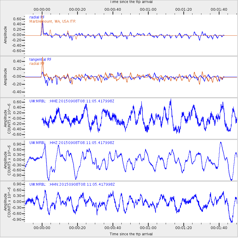
MRBL Marblemount, WA, USA - Earthquake Result Viewer
*The percent match for this event was below the threshold and hence no stack was calculated.
| Earthquake location: |
Near Coast Of Chiapas, Mexico |
| Earthquake latitude/longitude: |
14.7/-93.9 |
| Earthquake time(UTC): |
2015/09/08 (251) 08:03:54 GMT |
| Earthquake Depth: |
4.1 km |
| Earthquake Magnitude: |
5.5 MB, 5.7 MWB |
| Earthquake Catalog/Contributor: |
NEIC PDE/NEIC COMCAT |
|
| Network: |
UW Pacific Northwest Regional Seismic Network |
| Station: |
MRBL Marblemount, WA, USA |
| Lat/Lon: |
48.52 N/121.48 W |
| Elevation: |
75 m |
|
| Distance: |
40.7 deg |
| Az: |
331.807 deg |
| Baz: |
136.551 deg |
| Ray Param: |
$rayparam |
*The percent match for this event was below the threshold and hence was not used in the summary stack. |
|
| Radial Match: |
63.622986 % |
| Radial Bump: |
400 |
| Transverse Match: |
67.594574 % |
| Transverse Bump: |
386 |
| SOD ConfigId: |
7422571 |
| Insert Time: |
2019-04-20 17:36:49.833 +0000 |
| GWidth: |
2.5 |
| Max Bumps: |
400 |
| Tol: |
0.001 |
|
Signal To Noise
| Channel | StoN | STA | LTA |
| UW:MRBL: :HHZ:20150908T08:11:05.417998Z | 3.8260787 | 6.5388986E-7 | 1.709034E-7 |
| UW:MRBL: :HHN:20150908T08:11:05.417998Z | 2.833323 | 3.7151312E-7 | 1.3112275E-7 |
| UW:MRBL: :HHE:20150908T08:11:05.417998Z | 1.539787 | 2.5099735E-7 | 1.6300783E-7 |
| Arrivals |
| Ps | |
| PpPs | |
| PsPs/PpSs | |


