You are here: Home > Network List > TA - USArray Transportable Network (new EarthScope stations) Stations List
> Station M53A WI Miller and Sons, Farmdale, OH, USA > Earthquake Result Viewer
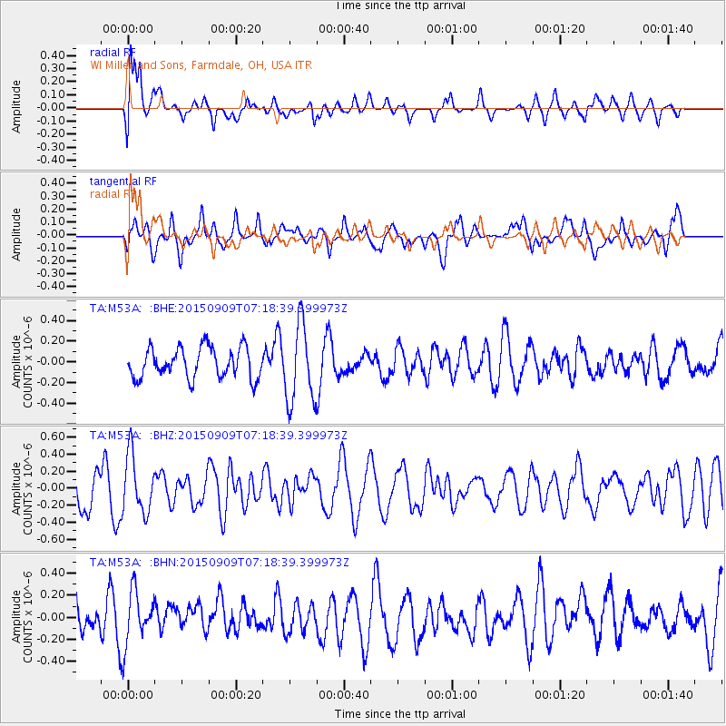
M53A WI Miller and Sons, Farmdale, OH, USA - Earthquake Result Viewer
*The percent match for this event was below the threshold and hence no stack was calculated.
| Earthquake location: |
Southern East Pacific Rise |
| Earthquake latitude/longitude: |
-49.5/-116.3 |
| Earthquake time(UTC): |
2015/09/09 (252) 07:05:44 GMT |
| Earthquake Depth: |
10 km |
| Earthquake Magnitude: |
5.7 MWC, 5.7 MWC |
| Earthquake Catalog/Contributor: |
NEIC PDE/NEIC COMCAT |
|
| Network: |
TA USArray Transportable Network (new EarthScope stations) |
| Station: |
M53A WI Miller and Sons, Farmdale, OH, USA |
| Lat/Lon: |
41.44 N/80.68 W |
| Elevation: |
334 m |
|
| Distance: |
95.9 deg |
| Az: |
26.118 deg |
| Baz: |
202.424 deg |
| Ray Param: |
$rayparam |
*The percent match for this event was below the threshold and hence was not used in the summary stack. |
|
| Radial Match: |
79.48337 % |
| Radial Bump: |
400 |
| Transverse Match: |
50.516373 % |
| Transverse Bump: |
400 |
| SOD ConfigId: |
7422571 |
| Insert Time: |
2019-04-20 17:47:51.300 +0000 |
| GWidth: |
2.5 |
| Max Bumps: |
400 |
| Tol: |
0.001 |
|
Signal To Noise
| Channel | StoN | STA | LTA |
| TA:M53A: :BHZ:20150909T07:18:39.399973Z | 1.8050861 | 3.3948052E-7 | 1.8806887E-7 |
| TA:M53A: :BHN:20150909T07:18:39.399973Z | 1.5564052 | 2.353464E-7 | 1.5121154E-7 |
| TA:M53A: :BHE:20150909T07:18:39.399973Z | 2.6209526 | 3.838042E-7 | 1.4643692E-7 |
| Arrivals |
| Ps | |
| PpPs | |
| PsPs/PpSs | |


