You are here: Home > Network List > CI - Caltech Regional Seismic Network Stations List
> Station GSC Goldstone, Goldstone Lake, CA, USA > Earthquake Result Viewer
GSC Goldstone, Goldstone Lake, CA, USA - Earthquake Result Viewer
| Earthquake location: |
Near Coast Of Central Chile |
| Earthquake latitude/longitude: |
-30.6/-71.6 |
| Earthquake time(UTC): |
2003/06/20 (171) 13:30:41 GMT |
| Earthquake Depth: |
33 km |
| Earthquake Magnitude: |
6.4 MB, 6.8 MS, 6.8 MW, 6.7 MW |
| Earthquake Catalog/Contributor: |
WHDF/NEIC |
|
| Network: |
CI Caltech Regional Seismic Network |
| Station: |
GSC Goldstone, Goldstone Lake, CA, USA |
| Lat/Lon: |
35.30 N/116.81 W |
| Elevation: |
1000 m |
|
| Distance: |
78.1 deg |
| Az: |
323.647 deg |
| Baz: |
141.333 deg |
| Ray Param: |
0.049806334 |
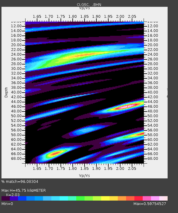
| Estimated Moho Depth: |
45.75 km |
| Estimated Crust Vp/Vs: |
2.03 |
| Assumed Crust Vp: |
6.276 km/s |
| Estimated Crust Vs: |
3.092 km/s |
| Estimated Crust Poisson's Ratio: |
0.34 |
|
| Radial Match: |
96.08304 % |
| Radial Bump: |
400 |
| Transverse Match: |
89.49003 % |
| Transverse Bump: |
400 |
| SOD ConfigId: |
3787 |
| Insert Time: |
2010-02-25 23:42:28.366 +0000 |
| GWidth: |
2.5 |
| Max Bumps: |
400 |
| Tol: |
0.001 |
|
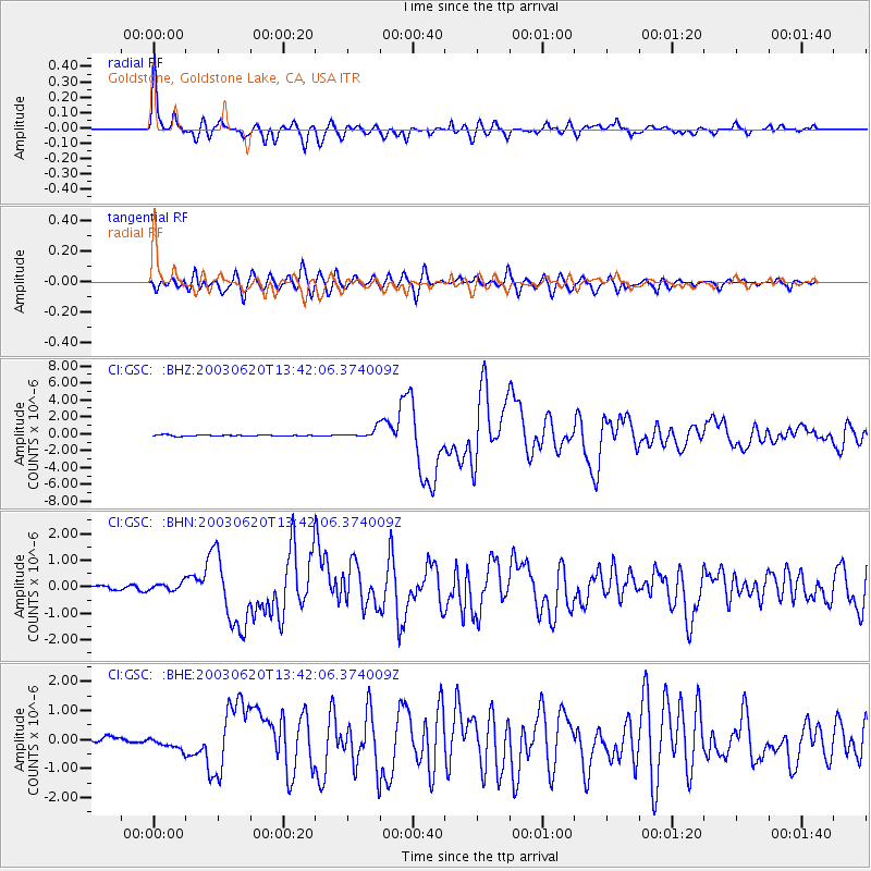
Signal To Noise
| Channel | StoN | STA | LTA |
| CI:GSC: :BHN:20030620T13:42:06.374009Z | 1.6184232 | 1.4400744E-7 | 8.898009E-8 |
| CI:GSC: :BHE:20030620T13:42:06.374009Z | 1.0928178 | 1.6605058E-7 | 1.5194718E-7 |
| CI:GSC: :BHZ:20030620T13:42:06.374009Z | 7.0694795 | 5.4048326E-7 | 7.645305E-8 |
| Arrivals |
| Ps | 7.7 SECOND |
| PpPs | 22 SECOND |
| PsPs/PpSs | 29 SECOND |


