You are here: Home > Network List > TA - USArray Transportable Network (new EarthScope stations) Stations List
> Station K61A Williamstown, MA, USA > Earthquake Result Viewer
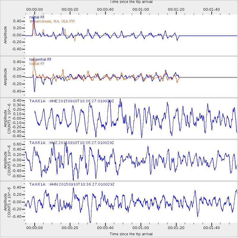
K61A Williamstown, MA, USA - Earthquake Result Viewer
*The percent match for this event was below the threshold and hence no stack was calculated.
| Earthquake location: |
Fox Islands, Aleutian Islands |
| Earthquake latitude/longitude: |
52.2/-169.6 |
| Earthquake time(UTC): |
2015/09/10 (253) 10:26:47 GMT |
| Earthquake Depth: |
38 km |
| Earthquake Magnitude: |
5.9 MWP, 5.9 MI |
| Earthquake Catalog/Contributor: |
NEIC PDE/NEIC COMCAT |
|
| Network: |
TA USArray Transportable Network (new EarthScope stations) |
| Station: |
K61A Williamstown, MA, USA |
| Lat/Lon: |
42.67 N/73.27 W |
| Elevation: |
391 m |
|
| Distance: |
61.2 deg |
| Az: |
56.791 deg |
| Baz: |
315.671 deg |
| Ray Param: |
$rayparam |
*The percent match for this event was below the threshold and hence was not used in the summary stack. |
|
| Radial Match: |
64.60972 % |
| Radial Bump: |
324 |
| Transverse Match: |
69.034485 % |
| Transverse Bump: |
396 |
| SOD ConfigId: |
7422571 |
| Insert Time: |
2019-04-20 17:58:20.745 +0000 |
| GWidth: |
2.5 |
| Max Bumps: |
400 |
| Tol: |
0.001 |
|
Signal To Noise
| Channel | StoN | STA | LTA |
| TA:K61A: :HHZ:20150910T10:36:27.010029Z | 1.7255985 | 3.242433E-7 | 1.8790193E-7 |
| TA:K61A: :HHN:20150910T10:36:27.010029Z | 0.9301421 | 1.3180147E-7 | 1.4170035E-7 |
| TA:K61A: :HHE:20150910T10:36:27.010029Z | 1.756178 | 2.4455275E-7 | 1.3925282E-7 |
| Arrivals |
| Ps | |
| PpPs | |
| PsPs/PpSs | |


